
Carte topographique Western Ghats
Cliquez sur la carte pour afficher l’altitude.
Western Ghats
Son altitude moyenne est de 1 200 mètres et ses sommets les plus élevés, dans la partie nord de la chaîne, au Maharashtra, sont le Kalsubai 1 646 m, le Mahabaleshwar 1 438 m et l'Harishchandragarh 1 424 m et dans la partie sud, le Kudremukh avec 1 862 m, dans le Karnataka. Paradoxalement c'est dans la partie sud qu'on trouve le plus haut sommet : Anamudi au Kerala avec ses 2 695 m. La trouée de Palghat (Palghat Gap), située entre les Nilgiri au nord et les Anaimalai au sud, large d'une trentaine de kilomètres, est la seule passe importante dans les Ghats occidentaux, elle permet de relier le Tamil Nadu au Kerala. Des chaînes de dimensions plus modestes, comme les Nilgiri au nord-ouest du Tamil Nadu et les Biligirirangan au sud-est du Karnataka près de Chennai, rejoignent les Shevaroy – ou chaîne des Servarayan – et la chaîne de Tirumalai, reliant les Ghats occidentaux aux Ghats orientaux. Elles servent de corridors importants pour la faune.
À propos de cette carte
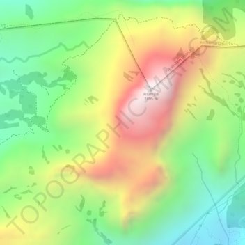
Nom : Carte topographique Western Ghats, altitude, relief.
Altitude moyenne : 2 225 m
Altitude minimum : 1 828 m
Altitude maximum : 2 685 m