
Carte topographique Éguzon-Chantôme
Carte interactive
Cliquez sur la carte pour afficher l’altitude.
À propos de cette carte
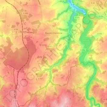
Nom : Carte topographique Éguzon-Chantôme, altitude, relief.
Altitude moyenne : 264 m
Altitude minimum : 145 m
Altitude maximum : 337 m
Autres cartes topographiques
Cliquez sur une carte pour visualiser sa topographie, son altitude et son relief.
Ardentes
France > Centre-Val de Loire > Indre
Ardentes, Châteauroux, Indre, Centre-Val de Loire, France métropolitaine, 36120, France
Altitude moyenne : 173 m
Châteauroux
France > Centre-Val de Loire > Indre > Châteauroux
Châteauroux, Indre, Centre-Val de Loire, France métropolitaine, 36000, France
Altitude moyenne : 153 m
Anjouin
France > Centre-Val de Loire > Indre
Anjouin, Issoudun, Indre, Centre-Val de Loire, France métropolitaine, 36210, France
Altitude moyenne : 124 m
Les Maisons Neuves
France > Centre-Val de Loire > Indre > Velles
Les Maisons Neuves, Velles, Châteauroux, Indre, Centre-Val de Loire, France métropolitaine, 36330, France
Altitude moyenne : 162 m
Bonneuil
France > Centre-Val de Loire > Indre
Bonneuil, Le Blanc, Indre, Centre-Val de Loire, France métropolitaine, 36310, France
Altitude moyenne : 206 m
Tournon-Saint-Martin
France > Centre-Val de Loire > Indre
Tournon-Saint-Martin, Le Blanc, Indre, Centre-Val de Loire, France métropolitaine, 36220, France
Altitude moyenne : 96 m
Luçay-le-Mâle
France > Centre-Val de Loire > Indre
Luçay-le-Mâle, Châteauroux, Indre, Centre-Val de Loire, France métropolitaine, 36360, France
Altitude moyenne : 149 m
Montaigu
France > Centre-Val de Loire > Indre > Pouligny-Saint-Pierre
Montaigu, Pouligny-Saint-Pierre, Le Blanc, Indre, Centre-Val de Loire, France métropolitaine, 36300, France
Altitude moyenne : 113 m
Lye
France > Centre-Val de Loire > Indre
Lye, Châteauroux, Indre, Centre-Val de Loire, France métropolitaine, 36600, France
Altitude moyenne : 111 m
Condé
France > Centre-Val de Loire > Indre
Condé, Issoudun, Indre, Centre-Val de Loire, France métropolitaine, 36100, France
Altitude moyenne : 152 m
La Vernelle
France > Centre-Val de Loire > Indre
La Vernelle, Châteauroux, Indre, Centre-Val de Loire, France métropolitaine, 36600, France
Altitude moyenne : 94 m
Pérassay
France > Centre-Val de Loire > Indre
Pérassay, La Châtre, Indre, Centre-Val de Loire, France métropolitaine, 36160, France
Altitude moyenne : 362 m
Boulaie
France > Centre-Val de Loire > Indre > Saint-Genou
Boulaie, Saint-Genou, Châteauroux, Indre, Centre-Val de Loire, France métropolitaine, 36500, France
Altitude moyenne : 125 m
Saint-Plantaire
France > Centre-Val de Loire > Indre
Saint-Plantaire, La Châtre, Indre, Centre-Val de Loire, France métropolitaine, 36190, France
Altitude moyenne : 295 m
Pouligny-Notre-Dame
France > Centre-Val de Loire > Indre
Pouligny-Notre-Dame, La Châtre, Indre, Centre-Val de Loire, France métropolitaine, 36160, France
Altitude moyenne : 350 m
Nohant-Vic
France > Centre-Val de Loire > Indre
Nohant-Vic, La Châtre, Indre, Centre-Val de Loire, France métropolitaine, 36400, France
Altitude moyenne : 217 m
Saint-Martin-de-Lamps
France > Centre-Val de Loire > Indre > Levroux
Saint-Martin-de-Lamps, Levroux, Châteauroux, Indre, Centre-Val de Loire, France métropolitaine, 36110, France
Altitude moyenne : 150 m
Vicq-sur-Nahon
France > Centre-Val de Loire > Indre
Vicq-sur-Nahon, Châteauroux, Indre, Centre-Val de Loire, France métropolitaine, 36600, France
Altitude moyenne : 148 m
Concremiers
France > Centre-Val de Loire > Indre
Concremiers, Le Blanc, Indre, Centre-Val de Loire, France métropolitaine, 36300, France
Altitude moyenne : 112 m
Mézières-en-Brenne
France > Centre-Val de Loire > Indre
Mézières-en-Brenne, Le Blanc, Indre, Centre-Val de Loire, France métropolitaine, 36290, France
Altitude moyenne : 100 m
Le Pêchereau
France > Centre-Val de Loire > Indre
Le Pêchereau, Châteauroux, Indre, Centre-Val de Loire, France métropolitaine, 36200, France
Altitude moyenne : 165 m
Bouesse
France > Centre-Val de Loire > Indre
Bouesse, Châteauroux, Indre, Centre-Val de Loire, France métropolitaine, 36200, France
Altitude moyenne : 187 m
Série
France > Centre-Val de Loire > Indre > Cluis
Série, Cluis, La Châtre, Indre, Centre-Val de Loire, France métropolitaine, 36340, France
Altitude moyenne : 264 m
Le Moulin Neuf
France > Centre-Val de Loire > Indre > Le Menoux
Le Moulin Neuf, Le Menoux, Châteauroux, Indre, Centre-Val de Loire, France métropolitaine, 36200, France
Altitude moyenne : 164 m
Roussines
France > Centre-Val de Loire > Indre
Roussines, Le Blanc, Indre, Centre-Val de Loire, France métropolitaine, 36170, France
Altitude moyenne : 211 m
Gargilesse-Dampierre
France > Centre-Val de Loire > Indre
Gargilesse-Dampierre, Châteauroux, Indre, Centre-Val de Loire, France métropolitaine, 36190, France
Altitude moyenne : 216 m
Varennes-sur-Fouzon
France > Centre-Val de Loire > Indre > Val-Fouzon
Varennes-sur-Fouzon, Val-Fouzon, Issoudun, Indre, Centre-Val de Loire, France métropolitaine, 36210, France
Altitude moyenne : 100 m
Briantes
France > Centre-Val de Loire > Indre
Briantes, La Châtre, Indre, Centre-Val de Loire, France métropolitaine, 36400, France
Altitude moyenne : 251 m
Gehée
France > Centre-Val de Loire > Indre
Gehée, Châteauroux, Indre, Centre-Val de Loire, France métropolitaine, 36240, France
Altitude moyenne : 142 m
Montgivray
France > Centre-Val de Loire > Indre
Montgivray, La Châtre, Indre, Centre-Val de Loire, France métropolitaine, 36400, France
Altitude moyenne : 223 m
Luzeret
France > Centre-Val de Loire > Indre
Luzeret, Le Blanc, Indre, Centre-Val de Loire, France métropolitaine, 36800, France
Altitude moyenne : 170 m
La Jarrige
France > Centre-Val de Loire > Indre > Douadic
La Jarrige, Douadic, Le Blanc, Indre, Centre-Val de Loire, France métropolitaine, 36300, France
Altitude moyenne : 103 m
Mérigny
France > Centre-Val de Loire > Indre
Mérigny, Le Blanc, Indre, Centre-Val de Loire, France métropolitaine, 36220, France
Altitude moyenne : 111 m
Le Poinçonnet
France > Centre-Val de Loire > Indre
Le Poinçonnet, Châteauroux, Indre, Centre-Val de Loire, France métropolitaine, 36330, France
Altitude moyenne : 164 m
Velles
France > Centre-Val de Loire > Indre
Velles, Châteauroux, Indre, Centre-Val de Loire, France métropolitaine, 36330, France
Altitude moyenne : 152 m
La Grande Métairie
France > Centre-Val de Loire > Indre > Bouesse
La Grande Métairie, Bouesse, Châteauroux, Indre, Centre-Val de Loire, France métropolitaine, 36200, France
Altitude moyenne : 190 m
Clion
France > Centre-Val de Loire > Indre
Clion, Châteauroux, Indre, Centre-Val de Loire, France métropolitaine, 36700, France
Altitude moyenne : 119 m
Ciron
France > Centre-Val de Loire > Indre
Ciron, Le Blanc, Indre, Centre-Val de Loire, France métropolitaine, 36300, France
Altitude moyenne : 121 m
Néons-sur-Creuse
France > Centre-Val de Loire > Indre
Néons-sur-Creuse, Le Blanc, Indre, Centre-Val de Loire, France métropolitaine, 36220, France
Altitude moyenne : 96 m
Chambrisse
France > Centre-Val de Loire > Indre > Châtillon-sur-Indre
Chambrisse, Châtillon-sur-Indre, Châteauroux, Indre, Centre-Val de Loire, France métropolitaine, 36700, France
Altitude moyenne : 121 m
Brenne
France > Centre-Val de Loire > Indre > Ardentes
Brenne, Ardentes, Châteauroux, Indre, Centre-Val de Loire, France métropolitaine, 36120, France
Altitude moyenne : 173 m
Bélâbre
France > Centre-Val de Loire > Indre
Bélâbre, Le Blanc, Indre, Centre-Val de Loire, France métropolitaine, 36370, France
Altitude moyenne : 126 m
Le Brolet
France > Centre-Val de Loire > Indre > Sazeray
Le Brolet, Sazeray, La Châtre, Indre, Centre-Val de Loire, France métropolitaine, 36160, France
Altitude moyenne : 402 m
Meunet-Planches
France > Centre-Val de Loire > Indre
Meunet-Planches, Issoudun, Indre, Centre-Val de Loire, France métropolitaine, 36100, France
Altitude moyenne : 157 m
Saint-Denis-de-Jouhet
France > Centre-Val de Loire > Indre
Saint-Denis-de-Jouhet, La Châtre, Indre, Centre-Val de Loire, France métropolitaine, 36230, France
Altitude moyenne : 294 m
Lourouer-Saint-Laurent
France > Centre-Val de Loire > Indre
Lourouer-Saint-Laurent, La Châtre, Indre, Centre-Val de Loire, France métropolitaine, 36400, France
Altitude moyenne : 213 m
Brives
France > Centre-Val de Loire > Indre
Brives, Issoudun, Indre, Centre-Val de Loire, France métropolitaine, 36100, France
Altitude moyenne : 155 m
Sainte-Sévère-sur-Indre
France > Centre-Val de Loire > Indre
Sainte-Sévère-sur-Indre, La Châtre, Indre, Centre-Val de Loire, France métropolitaine, 36160, France
Altitude moyenne : 287 m
Arthon
France > Centre-Val de Loire > Indre
Arthon, Châteauroux, Indre, Centre-Val de Loire, France métropolitaine, 36330, France
Altitude moyenne : 156 m
Sazeray
France > Centre-Val de Loire > Indre
Sazeray, La Châtre, Indre, Centre-Val de Loire, France métropolitaine, 36160, France
Altitude moyenne : 351 m