Carte topographique Mount Bromo
Carte interactive
Cliquez sur la carte pour afficher l’altitude.
À propos de cette carte
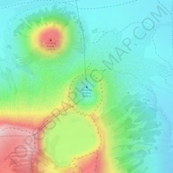
Nom : Carte topographique Mount Bromo, altitude, relief.
Lieu : Mount Bromo, Pasuruan, East Java, Java, 67254, Indonesia (-7.94212 112.95293 -7.94202 112.95303)
Altitude moyenne : 2 239 m
Altitude minimum : 2 110 m
Altitude maximum : 2 504 m
Further eruptions and the issuing of aviation ash advisories during the period 27–28 January 2011 led to concerns being raised regarding a volcanic ash plume, reported to be drifting eastward toward the air corridors used to access the Ngurah Rai International Airport IATA:DPS in Bali. Airport official Sherly Yunita was reported at the time as stating that concerns about visibility had prompted Singapore Airlines, Jetstar-ValueAir, Air France-KLM, Virgin Blue and Cathay Pacific to cancel several flights to Bali, 340 km (211 mi) to the east. SilkAir also cancelled flights on the 27 January between Singapore and Lombok, an island to the east of Bali. The Volcanic Ash Advisory Centre in Darwin, Australia released several Code Red Aviation Ash Advisories pertaining to Mount Bromo (Tengger Caldera), on 27 January. They indicated that ash was observed at altitudes up to 18,000 feet (5,486 m) (FL180) extending 200 nautical miles (370 km; 230 mi) to the south east of the caldera. In other ash advisories of that day the cloud was reported as at times having a 10 km/h (6.2 mph) drift, both to the east and to the south east.
Autres cartes topographiques
Cliquez sur une carte pour visualiser sa topographie, son altitude et son relief.
Bukit Cinta
Indonesia > East Java > Pasuruan
Bukit Cinta, Pasuruan, East Java, Java, 67254, Indonesia
Altitude moyenne : 2 309 m
Gondang Wetan
Indonesia > East Java > Pasuruan
Gondang Wetan, Pasuruan, East Java, Java, 67118, Indonesia
Altitude moyenne : 18 m
Sumber Pitu
Indonesia > East Java > Pasuruan
Sumber Pitu, Pasuruan, East Java, Java, 67163, Indonesia
Altitude moyenne : 738 m
Karang Sentul
Indonesia > East Java > Pasuruan
Karang Sentul, Pasuruan, East Java, 67174, Indonesia
Altitude moyenne : 26 m
Sengon Agung
Indonesia > East Java > Pasuruan
Sengon Agung, Pasuruan, East Java, Indonesia
Altitude moyenne : 275 m
Air Terjun Kakek Bodo
Indonesia > East Java > Pasuruan > Prigen
Air Terjun Kakek Bodo, Prigen, Pasuruan, East Java, Indonesia
Altitude moyenne : 947 m
Tanjungarum
Indonesia > East Java > Pasuruan > Tanjungarum
Tanjungarum, Pasuruan, East Java, 67161, Indonesia
Altitude moyenne : 229 m
Penanjakan
Indonesia > East Java > Pasuruan
Penanjakan, Pasuruan, East Java, Indonesia
Altitude moyenne : 2 427 m