
Carte topographique The Borough District of Wexford
Carte interactive
Cliquez sur la carte pour afficher l’altitude.
À propos de cette carte
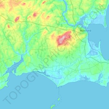
Nom : Carte topographique The Borough District of Wexford, altitude, relief.
Altitude moyenne : 29 m
Altitude minimum : -4 m
Altitude maximum : 225 m
Autres cartes topographiques
Cliquez sur une carte pour visualiser sa topographie, son altitude et son relief.
The Municipal District of Enniscorthy
The Municipal District of Enniscorthy, Comté de Wexford, Leinster, Irlande
Altitude moyenne : 108 m
Saint Vogue's
Saint Vogue's, Lady's Island ED, The Borough District of Wexford, Comté de Wexford, Leinster, Irlande
Altitude moyenne : 3 m
New Ross
New Ross, Comté de Wexford, Leinster, Irlande
Altitude moyenne : 39 m
Bellary
Bellary, Duncormick ED, The Borough District of Wexford, Comté de Wexford, Leinster, Irlande
Altitude moyenne : 13 m
Gorey
Gorey Corporation Townlands, Gorey, The Municipal District of Gorey — Kilmuckridge, Comté de Wexford, Leinster, Irlande
Altitude moyenne : 60 m