
Carte topographique Pico de Orizaba
Carte interactive
Cliquez sur la carte pour afficher l’altitude.
Pico de Orizaba
Le pic d'Orizaba ou Citlaltépetl est un volcan du Mexique, à la limite entre les États de Veracruz et Puebla. Culminant à 5 675 mètres d'altitude et situé dans la cordillère Néovolcanique, il constitue le point culminant du pays et de cette chaîne de montagnes, mais également le plus haut volcan d'Amérique du Nord ce qui en fait un des sept sommets volcaniques. Sa dernière éruption remonte à 1846. Sa première ascension officielle a lieu deux ans plus tard, à la fin de la Guerre américano-mexicaine, par les lieutenants américains F. Maynard et G. Reynolds.
À propos de cette carte
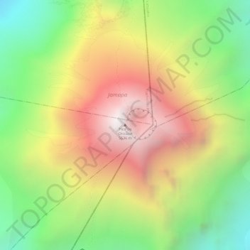
Nom : Carte topographique Pico de Orizaba, altitude, relief.
Lieu : Pico de Orizaba, Chalchicomula de Sesma, Pue, Mexique (19.03028 -97.26987 19.03038 -97.26977)
Altitude moyenne : 4 969 m
Altitude minimum : 4 327 m
Altitude maximum : 5 589 m