
Carte topographique South District
Carte interactive
Cliquez sur la carte pour afficher l’altitude.
À propos de cette carte
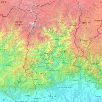
Nom : Carte topographique South District, altitude, relief.
Lieu : South District, Namchi District, Sikkim, 737139, Inde (26.63333 87.71667 28.03333 89.11667)
Altitude moyenne : 2 687 m
Altitude minimum : 73 m
Altitude maximum : 8 402 m
Autres cartes topographiques
Cliquez sur une carte pour visualiser sa topographie, son altitude et son relief.
Rangpo
Inde > Sikkim > Pakyong subdivision
Rangpo, Pakyong subdivision, Pakyong District, Sikkim, 737132, Inde
Altitude moyenne : 731 m
Lachung
Inde > Sikkim > Chungthang
Lachung, Chungthang, Mangan District, Sikkim, Inde
Altitude moyenne : 3 617 m
East Sikkim District
Inde > Sikkim > Pakyong subdivision
East Sikkim District, Pakyong subdivision, Pakyong district, Sikkim, Inde
Altitude moyenne : 2 107 m
North District
North District, North Sikkim District, Sikkim, Inde
Altitude moyenne : 3 842 m