
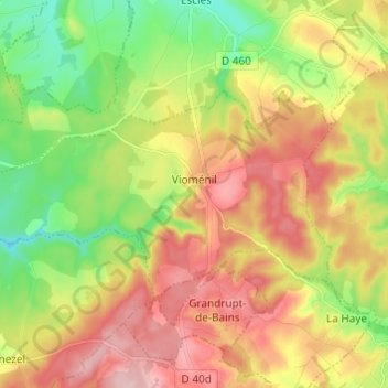
Carte topographique Vioménil
Carte interactive
Cliquez sur la carte pour afficher l’altitude.
À propos de cette carte
Nom : Carte topographique Vioménil, altitude, relief.
Altitude moyenne : 390 m
Altitude minimum : 303 m
Altitude maximum : 484 m
La Saône prend sa source sur le territoire communal au pied du Ménamont, au sud des monts Faucilles à 405 m d'altitude. Elle conflue avec le Rhône à Lyon, à l'altitude de 163 mètres après avoir traversé le val de Saône.
Autres cartes topographiques
Cliquez sur une carte pour visualiser sa topographie, son altitude et son relief.
Saint-Dié-des-Vosges
Saint-Dié-des-Vosges, Vosges, Grand Est, France métropolitaine, 88100, France
Altitude moyenne : 433 m
La Neuveville-sous-Montfort
La Neuveville-sous-Montfort, Neufchâteau, Vosges, Grand Est, France métropolitaine, 88800, France
Altitude moyenne : 376 m
Xonrupt-Longemer
Xonrupt-Longemer, Saint-Dié-des-Vosges, Vosges, Grand Est, France métropolitaine, 88400, France
Altitude moyenne : 896 m
Damas-et-Bettegney
Damas-et-Bettegney, Épinal, Vosges, Grand Est, France métropolitaine, 88270, France
Altitude moyenne : 349 m
Frenelle-la-Grande
Frenelle-la-Grande, Épinal, Vosges, Grand Est, France métropolitaine, 88500, France
Altitude moyenne : 299 m
Évaux-et-Ménil
Évaux-et-Ménil, Épinal, Vosges, Grand Est, France métropolitaine, 88450, France
Altitude moyenne : 330 m
Frenelle-la-Petite
Frenelle-la-Petite, Épinal, Vosges, Grand Est, France métropolitaine, 88500, France
Altitude moyenne : 304 m
Gruey-lès-Surance
Gruey-lès-Surance, Épinal, Vosges, Grand Est, France métropolitaine, 88240, France
Altitude moyenne : 415 m
Grandvillers
Grandvillers, Épinal, Vosges, Grand Est, France métropolitaine, 88600, France
Altitude moyenne : 403 m
Barbey-Seroux
Barbey-Seroux, Saint-Dié-des-Vosges, Vosges, Grand Est, France métropolitaine, 88640, France
Altitude moyenne : 684 m
Dombasle-devant-Darney
Dombasle-devant-Darney, Neufchâteau, Vosges, Grand Est, France métropolitaine, 88260, France
Altitude moyenne : 339 m
They-sous-Montfort
They-sous-Montfort, Neufchâteau, Vosges, Grand Est, France métropolitaine, 88800, France
Altitude moyenne : 396 m
Saut le Cerf
France > Grand Est > Vosges > Épinal
Saut le Cerf, Épinal, Vosges, Grand Est, France métropolitaine, 88000, France
Altitude moyenne : 349 m
Liffol-le-Grand
Liffol-le-Grand, Neufchâteau, Vosges, Grand Est, France métropolitaine, 88350, France
Altitude moyenne : 360 m
Faymont
France > Grand Est > Vosges > Le Val-d'Ajol
Faymont, Le Val-d'Ajol, Épinal, Vosges, Grand Est, France métropolitaine, 88340, France
Altitude moyenne : 533 m
Fruze
France > Grand Est > Vosges > Soulosse-sous-Saint-Élophe
Fruze, Soulosse-sous-Saint-Élophe, Neufchâteau, Vosges, Grand Est, France métropolitaine, 88630, France
Altitude moyenne : 324 m
Pargny-sous-Mureau
Pargny-sous-Mureau, Neufchâteau, Vosges, Grand Est, France métropolitaine, 88350, France
Altitude moyenne : 358 m
Le Beillard
France > Grand Est > Vosges > Liézey
Le Beillard, Liézey, Saint-Dié-des-Vosges, Vosges, Grand Est, France métropolitaine, 88400, France
Altitude moyenne : 676 m
Saint-Jean-du-Marché
France > Grand Est > Vosges > La Neuveville-devant-Lépanges
Saint-Jean-du-Marché, La Neuveville-devant-Lépanges, Épinal, Vosges, Grand Est, France métropolitaine, 88600, France
Altitude moyenne : 504 m
Tremblois
France > Grand Est > Vosges > Domvallier
Tremblois, Domvallier, Épinal, Vosges, Grand Est, France métropolitaine, 88500, France
Altitude moyenne : 313 m
88150
France > Grand Est > Vosges > Thaon-les-Vosges
88150, Thaon-les-Vosges, Épinal, Vosges, Grand Est, France métropolitaine, France
Altitude moyenne : 312 m
Ferme du Chesnois
France > Grand Est > Vosges > La Vôge-les-Bains
Ferme du Chesnois, Bains-les-Bains, La Vôge-les-Bains, Épinal, Vosges, Grand Est, France métropolitaine, 88240, France
Altitude moyenne : 333 m
La Houssière
La Houssière, Saint-Dié-des-Vosges, Vosges, Grand Est, France métropolitaine, 88430, France
Altitude moyenne : 530 m
Martigny-les-Bains
Martigny-les-Bains, Neufchâteau, Vosges, Grand Est, France métropolitaine, 88320, France
Altitude moyenne : 398 m
Damas-aux-Bois
Damas-aux-Bois, Épinal, Vosges, Grand Est, France métropolitaine, 88330, France
Altitude moyenne : 328 m
Les Gérard
France > Grand Est > Vosges > Le Val-d'Ajol
Les Gérard, Le Val-d'Ajol, Épinal, Vosges, Grand Est, France métropolitaine, 88340, France
Altitude moyenne : 565 m
Raon-sur-Plaine
Raon-sur-Plaine, Saint-Dié-des-Vosges, Vosges, Grand Est, France métropolitaine, 88110, France
Altitude moyenne : 594 m