
Faire un don
Équipez-vous pour votre prochaine aventure :
En tant que Partenaire Amazon, ce site perçoit une commission sur les achats éligibles sans surcoût pour vous.
Carte topographique Starý Smokovec
Cliquez sur la carte pour afficher l’altitude.
Faire un don
Équipez-vous pour votre prochaine aventure :
En tant que Partenaire Amazon, ce site perçoit une commission sur les achats éligibles sans surcoût pour vous.
À propos de cette carte
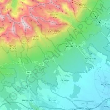
Nom : Carte topographique Starý Smokovec, altitude, relief.
Altitude moyenne : 1 065 m
Altitude minimum : 659 m
Altitude maximum : 2 611 m
Faire un don
Équipez-vous pour votre prochaine aventure :
En tant que Partenaire Amazon, ce site perçoit une commission sur les achats éligibles sans surcoût pour vous.
Autres cartes topographiques
Cliquez sur une carte pour visualiser sa topographie, son altitude et son relief.
Kriváň
Slovakia > Region of Prešov > District of Poprad > Vysoké Tatry
The relative elevations of the two mountains were determined by the English natural historian Robert Townson, who ascended both peaks in August 1793 and also made an early recorded comment on Kriváň's aesthetic appeal.
Altitude moyenne : 1 913 m
Medený vodopád
Slovakia > Region of Prešov > District of Poprad > Vysoké Tatry
Altitude moyenne : 2 004 m
Druhý Mních / Zadni Mnich
Slovakia > Region of Prešov > District of Poprad > Vysoké Tatry
Altitude moyenne : 1 921 m
Faire un don
Équipez-vous pour votre prochaine aventure :
En tant que Partenaire Amazon, ce site perçoit une commission sur les achats éligibles sans surcoût pour vous.