
Carte topographique Mont Snowdon
Carte interactive
Cliquez sur la carte pour afficher l’altitude.
Mont Snowdon
Le mont Snowdon, toponyme anglais signifiant « la colline enneigée » et en gallois Yr Wyddfa c'est-à-dire « le tumulus », est un sommet du Royaume-Uni qui s'élève à 1 085 mètres d'altitude et qui constitue le point culminant du massif Snowdon et du pays de Galles. Il se situe dans le comté du Gwynedd, au sein du parc national de Snowdonia, créé en 1951, et de diverses autres zones de conservation destinées à protéger sa faune et sa flore rares au Royaume-Uni. C'est l'un des endroits les plus arrosés du pays. Ses roches, formées au cours de l'Ordovicien, sont d'origine volcanique et ont été fortement érodées lors des glaciations. Ainsi, ses cirques abritent plusieurs lacs glaciaires.
À propos de cette carte
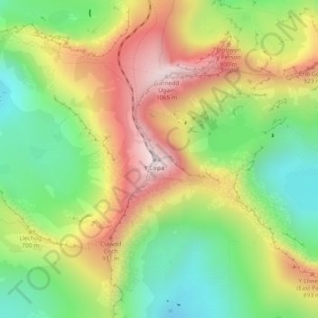
Nom : Carte topographique Mont Snowdon, altitude, relief.
Lieu : Mont Snowdon, Gwynedd, Pays de Galles, LL55 4UL, Royaume-Uni (53.06844 -4.07628 53.06854 -4.07618)
Altitude moyenne : 692 m
Altitude minimum : 390 m
Altitude maximum : 1 061 m
Autres cartes topographiques
Cliquez sur une carte pour visualiser sa topographie, son altitude et son relief.