
Carte topographique Bruschied
Carte interactive
Cliquez sur la carte pour afficher l’altitude.
À propos de cette carte
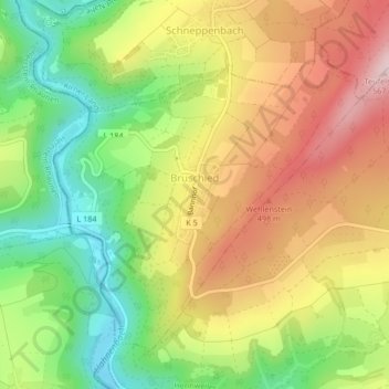
Nom : Carte topographique Bruschied, altitude, relief.
Altitude moyenne : 390 m
Altitude minimum : 239 m
Altitude maximum : 550 m
Autres cartes topographiques
Cliquez sur une carte pour visualiser sa topographie, son altitude et son relief.
Langenthal
Allemagne > Rhénanie-Palatinat > Landkreis Bad Kreuznach > Langenthal
Langenthal, Nahe-Glan, Landkreis Bad Kreuznach, Rhénanie-Palatinat, Allemagne
Altitude moyenne : 319 m