
Faire un don
Équipez-vous pour votre prochaine aventure :
En tant que Partenaire Amazon, ce site perçoit une commission sur les achats éligibles sans surcoût pour vous.
Carte topographique Großer Arber
Cliquez sur la carte pour afficher l’altitude.
Faire un don
Équipez-vous pour votre prochaine aventure :
En tant que Partenaire Amazon, ce site perçoit une commission sur les achats éligibles sans surcoût pour vous.
Großer Arber
Le Großer Arber est le sommet le plus élevé de la crête montagneuse de la forêt de Bavière, entre la Bavière et la Bohême. Situé en Allemagne, il culmine à 1 456 mètres d'altitude. Il est surnommé le « roi de la forêt de Bavière » (en allemand : König des Bayerischen Waldes).
Faire un don
Équipez-vous pour votre prochaine aventure :
En tant que Partenaire Amazon, ce site perçoit une commission sur les achats éligibles sans surcoût pour vous.
À propos de cette carte
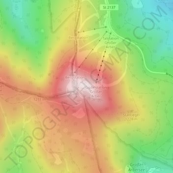
Nom : Carte topographique Großer Arber, altitude, relief.
Altitude moyenne : 1 141 m
Altitude minimum : 829 m
Altitude maximum : 1 445 m
Faire un don
Équipez-vous pour votre prochaine aventure :
En tant que Partenaire Amazon, ce site perçoit une commission sur les achats éligibles sans surcoût pour vous.