
Faire un don
Équipez-vous pour votre prochaine aventure :
En tant que Partenaire Amazon, ce site perçoit une commission sur les achats éligibles sans surcoût pour vous.
Carte topographique Everest
Cliquez sur la carte pour afficher l’altitude.
Faire un don
Équipez-vous pour votre prochaine aventure :
En tant que Partenaire Amazon, ce site perçoit une commission sur les achats éligibles sans surcoût pour vous.
Everest
Il est aperçu par des Européens pour la première fois en 1847 puis, après quelques années d'observations et de calculs, il est identifié comme le plus haut sommet du monde. Son altitude est établie à 8 849 mètres. Cette caractéristique lui vaut d'être baptisé de son nom actuel par les Occidentaux en 1865 en l'honneur de George Everest, arpenteur général des Indes orientales de 1830 à 1843, et, dès les années 1920, de susciter l'intérêt des alpinistes qui se lancent à l'assaut de ses faces. Plusieurs expéditions, en particulier britanniques, se succèdent depuis le versant nord au Tibet. Toutefois, les conditions météorologiques extrêmes font leurs premières victimes, parmi lesquelles George Mallory et Andrew Irvine, en 1924, dont on ne saura probablement jamais avec certitude s'ils ont atteint le sommet. En 1950, le Népal autorise l'accès à la montagne depuis le sud offrant des possibilités d'ascension par l'arête Sud-Est, moins périlleuse. Finalement, trois ans plus tard, le 29 mai 1953, Edmund Hillary et Tensing Norgay deviennent les premiers hommes à atteindre le sommet de l'Everest de manière certaine. Dès lors, les exploits en tous genres s'enchaînent, alimentant les fantasmes populaires ; mais, en 1996, une série d'accidents mortels vient rappeler les dangers liés à la montagne, portant de nos jours à plus de 200 le nombre de victimes. Pourtant, le tourisme de masse se généralise, fragilisant ce milieu naturel malgré les créations du parc national de Sagarmatha en 1976 et de la réserve naturelle du Qomolangma en 1988. Ainsi, plus de 14 000 alpinistes ont tenté l'ascension depuis 1922 et plus de 4 000 l'ont réussie, bien aidés, pour la majorité d'entre eux, par les porteurs sherpas et l'utilisation de bouteilles d'oxygène.
Faire un don
Équipez-vous pour votre prochaine aventure :
En tant que Partenaire Amazon, ce site perçoit une commission sur les achats éligibles sans surcoût pour vous.
À propos de cette carte
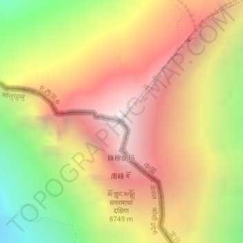
Nom : Carte topographique Everest, altitude, relief.
Lieu : Everest, Khumbupasanglahmu, Solukhumbu, Province n°1, Népal (27.98801 86.92516 27.98811 86.92526)
Altitude moyenne : 7 847 m
Altitude minimum : 6 597 m
Altitude maximum : 8 849 m
Faire un don
Équipez-vous pour votre prochaine aventure :
En tant que Partenaire Amazon, ce site perçoit une commission sur les achats éligibles sans surcoût pour vous.
Autres cartes topographiques
Cliquez sur une carte pour visualiser sa topographie, son altitude et son relief.