Géolocaliser
👉 Easily get elevation data in JSON, GeoTIFF and KML formats using Elevation API
Merci de soutenir ce site ❤️
Faire un don
🎯 Votre prochain emploi est peut-être à un message près : emploichat.fr

Carte topographique Daventry

Cliquez sur la carte pour afficher l’altitude.

👉 Easily get elevation data in JSON, GeoTIFF and KML formats using Elevation API
Merci de soutenir ce site ❤️
Faire un don
🎯 Votre prochain emploi est peut-être à un message près : emploichat.fr

Daventry

According to local folklore Daventry had Danish (Viking) origins, this was partly due to the old pronunciation of Daventry as Daintry, which was interpreted as "Dane Tree", however in more modern interpretation the town's name is thought likelier to be Anglo-Saxon in origin: "Dafa's tree" (Dafa being a founding father or paterfamila) and there was very likely a meeting tree, possibly on Borough Hill. Thus the name may have been formed on lines similar to Coventry ("Cofa's tree", i.e. "tree of Cofa"). Another theory which was popular in the 19th century, was that of Thomas Pennant, the Welsh naturalist and antiquarian, who acknowledged the town's 'considerable antiquity' and speculated that the name was Brythonic, dwy-avon-tre (town of two rivers), a derivation seemingly supported by the town's topography, situated as it is between the sources of the River Leam, which flows west, and the River Nene which flows east. This theory however is now discredited.

Wikipedia (CC-BY-SA 3.0)

À propos de cette carte

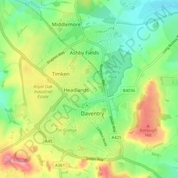
Nom : Carte topographique Daventry, altitude, relief.

Lieu : Daventry, West Northamptonshire, England, United Kingdom (52.24172 -1.19940 52.28750 -1.12449)

Altitude moyenne : 148 m

Altitude minimum : 102 m

Altitude maximum : 220 m

Autres cartes topographiques

Cliquez sur une carte pour visualiser sa topographie, son altitude et son relief.

Merci de soutenir ce site ❤️
Faire un don
🎯 Votre prochain emploi est peut-être à un message près : emploichat.fr

Watford

United Kingdom > England > West Northamptonshire

Altitude moyenne : 129 m

Hackleton

United Kingdom > England > West Northamptonshire

Altitude moyenne : 102 m

Tiffield

United Kingdom > England > West Northamptonshire

Altitude moyenne : 122 m

Foxley

United Kingdom > England > West Northamptonshire > Blakesley

Altitude moyenne : 139 m

Merci de soutenir ce site ❤️
Faire un don
🎯 Votre prochain emploi est peut-être à un message près : emploichat.fr

Whiston

United Kingdom > England > West Northamptonshire

Altitude moyenne : 66 m

Merci de soutenir ce site ❤️
Faire un don
🎯 Votre prochain emploi est peut-être à un message près : emploichat.fr
Merci de soutenir ce site ❤️
Faire un don
🎯 Votre prochain emploi est peut-être à un message près : emploichat.fr

Puxley

United Kingdom > England > West Northamptonshire

Altitude moyenne : 95 m

Merci de soutenir ce site ❤️
Faire un don
🎯 Votre prochain emploi est peut-être à un message près : emploichat.fr

Équipez-vous pour votre prochaine aventure :

🥾Chaussures de randonnée - Chaussures robustes et confortables pour randonnées sur sentiers et terrains variés
🎒Sacs de compression - Optimisation du volume dans le sac
🧴Lubrifiant Chaîne Vélo - Entretien pour conditions humides ou poussiéreuses
🧦Chaussettes Anti-Ampoules - Confort thermique et protection pour les longues marches
🧺Serviette Microfibre - Séchage ultra-rapide et encombrement minimal

En tant que Partenaire Amazon, ce site perçoit une commission sur les achats éligibles sans surcoût pour vous.