
Carte topographique City of Kingston
Carte interactive
Cliquez sur la carte pour afficher l’altitude.
À propos de cette carte
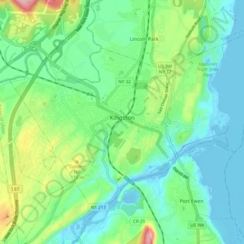
Nom : Carte topographique City of Kingston, altitude, relief.
Altitude moyenne : 52 m
Altitude minimum : -9 m
Altitude maximum : 199 m
Autres cartes topographiques
Cliquez sur une carte pour visualiser sa topographie, son altitude et son relief.
Eagle Mountain
États-Unis d'Amérique > New York > Ulster County
Eagle Mountain, Ulster County, New York, États-Unis d'Amérique
Altitude moyenne : 893 m
Rosendale
États-Unis d'Amérique > New York > Ulster County
Rosendale, Town of Rosendale, Ulster County, New York, 12472, États-Unis d'Amérique
Altitude moyenne : 65 m
Town of Woodstock
États-Unis d'Amérique > New York > Ulster County
Town of Woodstock, Ulster County, New York, États-Unis d'Amérique
Altitude moyenne : 332 m
High Falls
États-Unis d'Amérique > New York > Ulster County > Town of Marbletown
High Falls, Town of Marbletown, Ulster County, New York, États-Unis d'Amérique
Altitude moyenne : 77 m
Woodstock
États-Unis d'Amérique > New York > Ulster County > Woodstock
Woodstock, Town of Woodstock, Ulster County, New York, 12498, États-Unis d'Amérique
Altitude moyenne : 248 m
Phoenicia
États-Unis d'Amérique > New York > Ulster County > Town of Shandaken
Phoenicia, Town of Shandaken, Ulster County, New York, États-Unis d'Amérique
Altitude moyenne : 349 m