Géolocaliser

Carte topographique San Luis Potosí

Carte interactive

Cliquez sur la carte pour afficher l’altitude.

À propos de cette carte

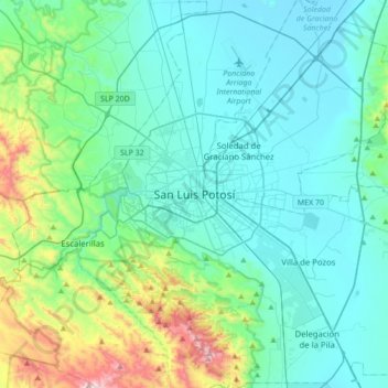
Nom : Carte topographique San Luis Potosí, altitude, relief.

Lieu : San Luis Potosí, Municipio de San Luis Potosí, San Luis Potosi, 78001, Mexico (21.99165 -101.13640 22.31165 -100.81640)

Altitude moyenne : 2 004 m

Altitude minimum : 1 826 m

Altitude maximum : 2 855 m

San Luis Potosí, commonly called SLP or simply San Luis, is the capital and the most populous city of the Mexican state of San Luis Potosí. It is the municipal seat of the surrounding municipality of San Luis Potosí. The city lies at an elevation of 1,864 metres (6,115 feet). It has an estimated population of 824,229 in the city proper and a population of approximately 1,221,526 in its metropolitan area, formed with the neighbour city of Soledad de Graciano Sánchez and other surrounding municipalities, which makes the metropolitan area of Greater San Luis Potosí the eleventh largest in Mexico.

Wikipedia (CC-BY-SA 3.0)

Autres cartes topographiques

Cliquez sur une carte pour visualiser sa topographie, son altitude et son relief.

Rotonda Florida

Mexico > San Luis Potosi > Municipio de San Luis Potosí

Rotonda Florida, Bosques La Florida, Municipio de San Luis Potosí, San Luis Potosi, Mexico

Altitude moyenne : 1 853 m