
Carte topographique Norman
Carte interactive
Cliquez sur la carte pour afficher l’altitude.
À propos de cette carte
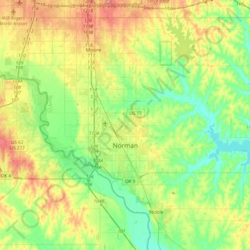
Nom : Carte topographique Norman, altitude, relief.
Lieu : Norman, Cleveland County, Oklahoma, États-Unis d'Amérique (35.14532 -97.54745 35.34832 -97.17692)
Altitude moyenne : 358 m
Altitude minimum : 317 m
Altitude maximum : 432 m
Autres cartes topographiques
Cliquez sur une carte pour visualiser sa topographie, son altitude et son relief.
SW Oklahoma City Sludge Lagoon Dam
États-Unis d'Amérique > Oklahoma > Cleveland County > Oklahoma City
Altitude moyenne : 348 m