
Carte topographique Staten Island
Carte interactive
Cliquez sur la carte pour afficher l’altitude.
À propos de cette carte
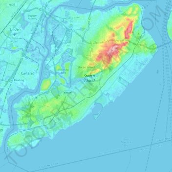
Nom : Carte topographique Staten Island, altitude, relief.
Lieu : Staten Island, Richmond County, New York, États-Unis (40.49603 -74.25568 40.64889 -74.04925)
Altitude moyenne : 11 m
Altitude minimum : -5 m
Altitude maximum : 122 m
Autres cartes topographiques
Cliquez sur une carte pour visualiser sa topographie, son altitude et son relief.
Teardrop Park
États-Unis > New York > New York
Teardrop Park, Battery Park City, Manhattan Community Board 1, Manhattan, New York County, New York, États-Unis
Altitude moyenne : 6 m
WCBS-AM (New York)
États-Unis > New York > New York
WCBS-AM (New York), Terrace Street, City Island, New York, The Bronx, Bronx County, New York, 10464, États-Unis
Altitude moyenne : 1 m
Manhattan
États-Unis > New York > New York
Yorkville, Manhattan Community Board 8, Manhattan, New York County, New York, États-Unis
Altitude moyenne : 19 m
Todt Hill
États-Unis > New York > New York
Todt Hill, Staten Island, Richmond County, New York, 10304, États-Unis
Altitude moyenne : 75 m