
Carte topographique Saint-Rémy-de-Provence
Carte interactive
Cliquez sur la carte pour afficher l’altitude.
À propos de cette carte
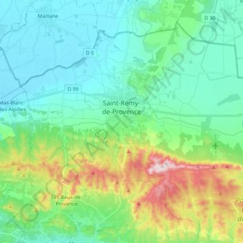
Nom : Carte topographique Saint-Rémy-de-Provence, altitude, relief.
Altitude moyenne : 100 m
Altitude minimum : 6 m
Altitude maximum : 388 m
Autres cartes topographiques
Cliquez sur une carte pour visualiser sa topographie, son altitude et son relief.
Marseille
France > Provence-Alpes-Côte d'Azur > Bouches-du-Rhône
Marseille, Bouches-du-Rhône, Provence-Alpes-Côte d'Azur, France métropolitaine, 13000, France
Altitude moyenne : 94 m
Aix-en-Provence
France > Provence-Alpes-Côte d'Azur > Bouches-du-Rhône
Aix-en-Provence, Bouches-du-Rhône, Provence-Alpes-Côte d'Azur, France métropolitaine, France
Altitude moyenne : 270 m
La Ciotat
France > Provence-Alpes-Côte d'Azur > Bouches-du-Rhône
La Ciotat, Marseille, Bouches-du-Rhône, Provence-Alpes-Côte d'Azur, France métropolitaine, 13600, France
Altitude moyenne : 89 m
Martigues
France > Provence-Alpes-Côte d'Azur > Bouches-du-Rhône
Martigues, Istres, Bouches-du-Rhône, Provence-Alpes-Côte d'Azur, France métropolitaine, France
Altitude moyenne : 35 m
Aubagne
France > Provence-Alpes-Côte d'Azur > Bouches-du-Rhône
Aubagne, Marseille, Bouches-du-Rhône, Provence-Alpes-Côte d'Azur, France métropolitaine, 13400, France
Altitude moyenne : 219 m
Cassis
France > Provence-Alpes-Côte d'Azur > Bouches-du-Rhône
Cassis, Marseille, Bouches-du-Rhône, Provence-Alpes-Côte d'Azur, France métropolitaine, 13260, France
Altitude moyenne : 150 m
Pas des Lanciers
France > Provence-Alpes-Côte d'Azur > Bouches-du-Rhône > Saint-Victoret
Pas des Lanciers, Saint-Victoret, Istres, Bouches-du-Rhône, Provence-Alpes-Côte d'Azur, France métropolitaine, 13700, France
Altitude moyenne : 75 m
Arles
France > Provence-Alpes-Côte d'Azur > Bouches-du-Rhône
Arles, Bouches-du-Rhône, Provence-Alpes-Côte d'Azur, France métropolitaine, France
Altitude moyenne : 13 m
Cabannes
France > Provence-Alpes-Côte d'Azur > Bouches-du-Rhône
Cabannes, Arles, Bouches-du-Rhône, Provence-Alpes-Côte d'Azur, France métropolitaine, 13440, France
Altitude moyenne : 51 m
Gréasque
France > Provence-Alpes-Côte d'Azur > Bouches-du-Rhône
Gréasque, Aix-en-Provence, Bouches-du-Rhône, Provence-Alpes-Côte d'Azur, France métropolitaine, 13850, France
Altitude moyenne : 355 m
13180
France > Provence-Alpes-Côte d'Azur > Bouches-du-Rhône > Gignac-la-Nerthe
13180, Laure, Gignac-la-Nerthe, Istres, Bouches-du-Rhône, Provence-Alpes-Côte d'Azur, France métropolitaine, France
Altitude moyenne : 56 m
Vitrolles
France > Provence-Alpes-Côte d'Azur > Bouches-du-Rhône
Vitrolles, Istres, Bouches-du-Rhône, Provence-Alpes-Côte d'Azur, France métropolitaine, 13127, France
Altitude moyenne : 80 m
Massif de l'Étoile
France > Provence-Alpes-Côte d'Azur > Bouches-du-Rhône > Mimet
Massif de l'Étoile, Mimet, Aix-en-Provence, Bouches-du-Rhône, Provence-Alpes-Côte d'Azur, France métropolitaine, 13105, France
Altitude moyenne : 514 m
Alleins
France > Provence-Alpes-Côte d'Azur > Bouches-du-Rhône
Alleins, Aix-en-Provence, Bouches-du-Rhône, Provence-Alpes-Côte d'Azur, France métropolitaine, 13980, France
Altitude moyenne : 168 m
Campagne Pastré
France > Provence-Alpes-Côte d'Azur > Bouches-du-Rhône > Marseille
Campagne Pastré, 8e Arrondissement, Marseille, Bouches-du-Rhône, Provence-Alpes-Côte d'Azur, France métropolitaine, 13008, France
Altitude moyenne : 85 m
13610
France > Provence-Alpes-Côte d'Azur > Bouches-du-Rhône > Le Puy-Sainte-Réparade
13610, Le Puy-Sainte-Réparade, Aix-en-Provence, Bouches-du-Rhône, Provence-Alpes-Côte d'Azur, France métropolitaine, France
Altitude moyenne : 216 m
Parc de la Poudrerie
France > Provence-Alpes-Côte d'Azur > Bouches-du-Rhône > Saint-Chamas
Parc de la Poudrerie, Saint-Chamas, Istres, Bouches-du-Rhône, Provence-Alpes-Côte d'Azur, France métropolitaine, 13250, France
Altitude moyenne : 31 m
13620
France > Provence-Alpes-Côte d'Azur > Bouches-du-Rhône > Carry-le-Rouet
13620, Carry-le-Rouet, Istres, Bouches-du-Rhône, Provence-Alpes-Côte d'Azur, France métropolitaine, France
Altitude moyenne : 98 m
Saint-Victoret
France > Provence-Alpes-Côte d'Azur > Bouches-du-Rhône
Saint-Victoret, Istres, Bouches-du-Rhône, Provence-Alpes-Côte d'Azur, France métropolitaine, 13730, France
Altitude moyenne : 37 m
Roquefavour
France > Provence-Alpes-Côte d'Azur > Bouches-du-Rhône > Ventabren
Roquefavour, Ventabren, Aix-en-Provence, Bouches-du-Rhône, Provence-Alpes-Côte d'Azur, France métropolitaine, 13122, France
Altitude moyenne : 166 m
13190
France > Provence-Alpes-Côte d'Azur > Bouches-du-Rhône > Allauch
13190, Allauch, Marseille, Bouches-du-Rhône, Provence-Alpes-Côte d'Azur, France métropolitaine, France
Altitude moyenne : 403 m
Étang de la Galére
France > Provence-Alpes-Côte d'Azur > Bouches-du-Rhône > Arles
Étang de la Galére, Arles, Bouches-du-Rhône, Provence-Alpes-Côte d'Azur, France métropolitaine, France
Altitude moyenne : -1 m
Parc Longchamp
France > Provence-Alpes-Côte d'Azur > Bouches-du-Rhône > Marseille
Parc Longchamp, 32, 4e Arrondissement, Marseille, Bouches-du-Rhône, Provence-Alpes-Côte d'Azur, France métropolitaine, 13004, France
Altitude moyenne : 57 m
Le Canet
France > Provence-Alpes-Côte d'Azur > Bouches-du-Rhône > Marseille
Le Canet, 14e Arrondissement, Marseille, Bouches-du-Rhône, Provence-Alpes-Côte d'Azur, France métropolitaine, 13014, France
Altitude moyenne : 32 m
Massif des Alpilles
France > Provence-Alpes-Côte d'Azur > Bouches-du-Rhône > Eyguières
Massif des Alpilles, Eyguières, Aix-en-Provence, Bouches-du-Rhône, Provence-Alpes-Côte d'Azur, France métropolitaine, 13430, France
Altitude moyenne : 247 m
Saint-Andiol
France > Provence-Alpes-Côte d'Azur > Bouches-du-Rhône
Saint-Andiol, Arles, Bouches-du-Rhône, Provence-Alpes-Côte d'Azur, France métropolitaine, 13670, France
Altitude moyenne : 54 m
Châteauneuf-le-Rouge
France > Provence-Alpes-Côte d'Azur > Bouches-du-Rhône
Châteauneuf-le-Rouge, Aix-en-Provence, Bouches-du-Rhône, Provence-Alpes-Côte d'Azur, France métropolitaine, 13790, France
Altitude moyenne : 286 m
13330
France > Provence-Alpes-Côte d'Azur > Bouches-du-Rhône > La Barben
13330, La Barben, Aix-en-Provence, Bouches-du-Rhône, Provence-Alpes-Côte d'Azur, France métropolitaine, France
Altitude moyenne : 118 m
Vernègues
France > Provence-Alpes-Côte d'Azur > Bouches-du-Rhône
Vernègues, Aix-en-Provence, Bouches-du-Rhône, Provence-Alpes-Côte d'Azur, France métropolitaine, 13116, France
Altitude moyenne : 226 m
Maillane
France > Provence-Alpes-Côte d'Azur > Bouches-du-Rhône
Maillane, Arles, Bouches-du-Rhône, Provence-Alpes-Côte d'Azur, France métropolitaine, 13910, France
Altitude moyenne : 12 m
Fos-sur-Mer
France > Provence-Alpes-Côte d'Azur > Bouches-du-Rhône
Fos-sur-Mer, Istres, Bouches-du-Rhône, Provence-Alpes-Côte d'Azur, France métropolitaine, 13270, France
Altitude moyenne : 10 m
Aurons
France > Provence-Alpes-Côte d'Azur > Bouches-du-Rhône
Aurons, Aix-en-Provence, Bouches-du-Rhône, Provence-Alpes-Côte d'Azur, France métropolitaine, 13121, France
Altitude moyenne : 245 m
Allauch
France > Provence-Alpes-Côte d'Azur > Bouches-du-Rhône
Allauch, Marseille, Bouches-du-Rhône, Provence-Alpes-Côte d'Azur, France métropolitaine, 13190, France
Altitude moyenne : 280 m
Cornillon-Confoux
France > Provence-Alpes-Côte d'Azur > Bouches-du-Rhône
Cornillon-Confoux, Istres, Bouches-du-Rhône, Provence-Alpes-Côte d'Azur, France métropolitaine, 13250, France
Altitude moyenne : 74 m
Simiane-Collongue
France > Provence-Alpes-Côte d'Azur > Bouches-du-Rhône
Simiane-Collongue, Aix-en-Provence, Bouches-du-Rhône, Provence-Alpes-Côte d'Azur, France métropolitaine, 13109, France
Altitude moyenne : 345 m
Le Canet
France > Provence-Alpes-Côte d'Azur > Bouches-du-Rhône > Meyreuil
Le Canet, Meyreuil, Aix-en-Provence, Bouches-du-Rhône, Provence-Alpes-Côte d'Azur, France métropolitaine, 13590, France
Altitude moyenne : 221 m
Saint-Antonin-sur-Bayon
France > Provence-Alpes-Côte d'Azur > Bouches-du-Rhône
Saint-Antonin-sur-Bayon, Aix-en-Provence, Bouches-du-Rhône, Provence-Alpes-Côte d'Azur, France métropolitaine, 13100, France
Altitude moyenne : 456 m
Le Pati
France > Provence-Alpes-Côte d'Azur > Bouches-du-Rhône > Martigues
Le Pati, Martigues, Istres, Bouches-du-Rhône, Provence-Alpes-Côte d'Azur, France métropolitaine, France
Altitude moyenne : 57 m
Auriol
France > Provence-Alpes-Côte d'Azur > Bouches-du-Rhône
Auriol, Marseille, Bouches-du-Rhône, Provence-Alpes-Côte d'Azur, France métropolitaine, 13390, France
Altitude moyenne : 337 m
La Pelouque
France > Provence-Alpes-Côte d'Azur > Bouches-du-Rhône > Marseille
La Pelouque, 16e Arrondissement, Marseille, Bouches-du-Rhône, Provence-Alpes-Côte d'Azur, France métropolitaine, 13016, France
Altitude moyenne : 120 m
La Barben
France > Provence-Alpes-Côte d'Azur > Bouches-du-Rhône
La Barben, Aix-en-Provence, Bouches-du-Rhône, Provence-Alpes-Côte d'Azur, France métropolitaine, 13330, France
Altitude moyenne : 118 m
Saint-Germain
France > Provence-Alpes-Côte d'Azur > Bouches-du-Rhône > Simiane-Collongue
Saint-Germain, Simiane-Collongue, Aix-en-Provence, Bouches-du-Rhône, Provence-Alpes-Côte d'Azur, France métropolitaine, 13109, France
Altitude moyenne : 363 m
Marignane
France > Provence-Alpes-Côte d'Azur > Bouches-du-Rhône
Marignane, Istres, Bouches-du-Rhône, Provence-Alpes-Côte d'Azur, France métropolitaine, 13700, France
Altitude moyenne : 24 m
Les Trois Arches
France > Provence-Alpes-Côte d'Azur > Bouches-du-Rhône > Marseille
Les Trois Arches, Sentier du Malvalon, Les Goudes, 8e Arrondissement, Marseille, Bouches-du-Rhône, Provence-Alpes-Côte d'Azur, France métropolitaine, 13008, France
Altitude moyenne : 159 m
Les Sansouïres des Rièges
France > Provence-Alpes-Côte d'Azur > Bouches-du-Rhône > Saintes-Maries-de-la-Mer
Les Sansouïres des Rièges, Saintes-Maries-de-la-Mer, Arles, Bouches-du-Rhône, Provence-Alpes-Côte d'Azur, France métropolitaine, 13460, France
Altitude moyenne : 0 m
Berre-l'Étang
France > Provence-Alpes-Côte d'Azur > Bouches-du-Rhône
Berre-l'Étang, Istres, Bouches-du-Rhône, Provence-Alpes-Côte d'Azur, France métropolitaine, 13130, France
Altitude moyenne : 38 m
Istres
France > Provence-Alpes-Côte d'Azur > Bouches-du-Rhône
Istres, Bouches-du-Rhône, Provence-Alpes-Côte d'Azur, France métropolitaine, France
Altitude moyenne : 33 m
Bouc-Bel-Air
France > Provence-Alpes-Côte d'Azur > Bouches-du-Rhône
Bouc-Bel-Air, Aix-en-Provence, Bouches-du-Rhône, Provence-Alpes-Côte d'Azur, France métropolitaine, 13320, France
Altitude moyenne : 227 m
Trets
France > Provence-Alpes-Côte d'Azur > Bouches-du-Rhône
Trets, Aix-en-Provence, Bouches-du-Rhône, Provence-Alpes-Côte d'Azur, France métropolitaine, 13530, France
Altitude moyenne : 349 m
Venelles
France > Provence-Alpes-Côte d'Azur > Bouches-du-Rhône
Venelles, Aix-en-Provence, Bouches-du-Rhône, Provence-Alpes-Côte d'Azur, France métropolitaine, 13770, France
Altitude moyenne : 349 m