
Carte topographique Belo Horizonte
Carte interactive
Cliquez sur la carte pour afficher l’altitude.
Belo Horizonte
La superficie de la commune est de 331,4 km2. L'altitude au centre de la ville est de 852 mètres, variant de 650 mètres à 1 538 mètres, la plus grande partie de la commune se situant entre 750 mètres et 1 000 mètres.
À propos de cette carte
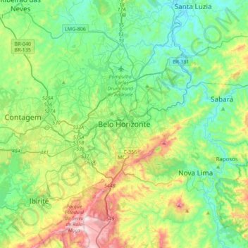
Nom : Carte topographique Belo Horizonte, altitude, relief.
Altitude moyenne : 904 m
Altitude minimum : 675 m
Altitude maximum : 1 508 m
Autres cartes topographiques
Cliquez sur une carte pour visualiser sa topographie, son altitude et son relief.
Belo Horizonte
Brésil > Minas Gerais > Região Metropolitana de Belo Horizonte
La superficie de la commune est de 331,4 km2. L'altitude au centre de la ville est de 852 mètres, variant de 650 mètres à 1 538 mètres, la plus grande partie de la commune se situant entre 750 mètres et 1 000 mètres.
Altitude moyenne : 895 m