Géolocaliser

Carte topographique Gruppo del Pomagagnon

Carte interactive

Cliquez sur la carte pour afficher l’altitude.

À propos de cette carte

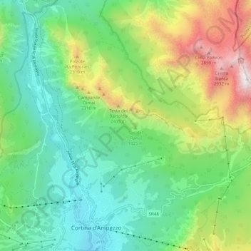
Nom : Carte topographique Gruppo del Pomagagnon, altitude, relief.

Lieu : Gruppo del Pomagagnon, Cortina d'Ampezzo, Belluno, Veneto, 32043, Italy (46.53203 12.11183 46.59910 12.20186)

Altitude moyenne : 1 758 m

Altitude minimum : 1 159 m

Altitude maximum : 3 085 m

Pomagagnon is a mountain of the Dolomites in Belluno, northern Italy. It has an elevation of 2,450 metres (8,038 ft) and is the southernmost mountain of the Cristallo Group, towering 1,200 metres (3,937 ft) over the resort of Cortina d'Ampezzo. The mountain is part of the "Natural Park of the Ampezzo Dolomites".

Wikipedia (CC-BY-SA 3.0)

Autres cartes topographiques

Cliquez sur une carte pour visualiser sa topographie, son altitude et son relief.

Falzarego Pass

Italy > Veneto > Belluno > Cortina d'Ampezzo

Falzarego Pass, Cortina d'Ampezzo, Belluno, Veneto, Italy

Altitude moyenne : 2 179 m

Pocol

Italy > Veneto > Belluno > Cortina d'Ampezzo

Pocol, Cortina d'Ampezzo, Belluno, Veneto, 32043, Italy

Altitude moyenne : 1 448 m

Cinque Torri

Italy > Veneto > Belluno > Cortina d'Ampezzo

Cinque Torri, Cortina d'Ampezzo, Belluno, Veneto, Italy

Altitude moyenne : 2 071 m