
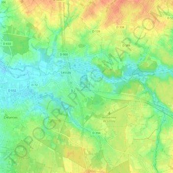
Carte topographique Lessay
Carte interactive
Cliquez sur la carte pour afficher l’altitude.
À propos de cette carte
Nom : Carte topographique Lessay, altitude, relief.
Altitude moyenne : 21 m
Altitude minimum : 2 m
Altitude maximum : 47 m
Autres cartes topographiques
Cliquez sur une carte pour visualiser sa topographie, son altitude et son relief.
Les Landelles
France > Normandie > Manche > Lessay
Les Landelles, Lessay, Coutances, Manche, Normandie, France métropolitaine, 50430, France
Altitude moyenne : 14 m
Sainte-Opportune
France > Normandie > Manche > Lessay
Sainte-Opportune, Lessay, Coutances, Manche, Normandie, France métropolitaine, 50430, France
Altitude moyenne : 19 m
Notre-Dame
France > Normandie > Manche > Lessay
Notre-Dame, Lessay, Coutances, Manche, Normandie, France métropolitaine, 50430, France
Altitude moyenne : 18 m