
Carte topographique Ségovie
Carte interactive
Cliquez sur la carte pour afficher l’altitude.
À propos de cette carte
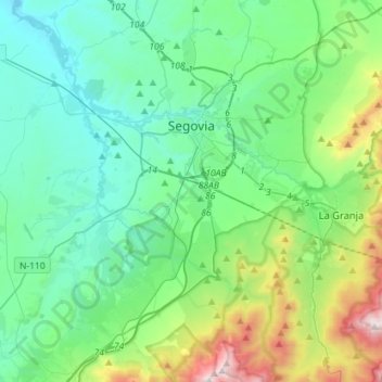
Nom : Carte topographique Ségovie, altitude, relief.
Lieu : Ségovie, Castille-et-León, Espagne (40.83472 -4.33675 40.98799 -4.05245)
Altitude moyenne : 1 143 m
Altitude minimum : 857 m
Altitude maximum : 2 193 m
Autres cartes topographiques
Cliquez sur une carte pour visualiser sa topographie, son altitude et son relief.
Posadilla de la Vega
Espagne > Castille-et-León > San Cristóbal de la Polantera
Altitude moyenne : 812 m
Le Douro
Espagne > Castille-et-León > Zamora
Le Douro [ˈdo(w)ɾu] (en portugais) ou Duero (en espagnol) est un fleuve qui prend sa source en Espagne à 2 160 m d'altitude, dans la sierra de Urbión appartenant à la cordillère Ibérique, dans la province de Sória. Il serpente à travers la Meseta pendant 572 km. Puis sur 112 km, il marque la…
Altitude moyenne : 636 m
Villafranca del Bierzo
Espagne > Castille-et-León > El Bierzo > Villafranca del Bierzo > Villafranca del Bierzo
Altitude moyenne : 602 m
Villanueva de la Peña
Espagne > Castille-et-León > Castrejón de la Peña > Villanueva de la Peña
Altitude moyenne : 1 240 m
Moncayo
Espagne > Castille-et-León > Ágreda
Le Moncayo, ou pico de San Miguel, est une montagne du Système ibérique située entre la province de Saragosse (Aragon, Espagne) et la province de Soria (Castille-et-León). Avec ses 2 314 m d'altitude c'est le plus haut sommet du système ibérique et l'un des pics les plus importants de la péninsule…
Altitude moyenne : 1 954 m
Astorga
Espagne > Castille-et-León > Astorga > Astorga
Astorga est située dans le nord-ouest de l'Espagne, sur un plateau, la Meseta, à une altitude de 850 m.
Altitude moyenne : 873 m
Boadilla del Camino
Espagne > Castille-et-León > Boadilla del Camino > Boadilla del Camino
Altitude moyenne : 788 m
Caín de Valdeon
Espagne > Castille-et-León > Posada de Valdeón > Caín de Valdeon
Altitude moyenne : 1 088 m
Villagonzalo-Arenas
Espagne > Castille-et-León > Burgos > Villagonzalo-Arenas
Altitude moyenne : 873 m
San Pedro de la Viña
Espagne > Castille-et-León > Santibáñez de Vidriales > San Pedro de la Viña
Altitude moyenne : 767 m
La Pradera de Navalhorno
Espagne > Castille-et-León > Real Sitio de San Ildefonso
Altitude moyenne : 1 236 m
Moral de Órbigo
Espagne > Castille-et-León > Villares de Órbigo > Moral de Órbigo
Altitude moyenne : 862 m