
Carte topographique Bendigo
Carte interactive
Cliquez sur la carte pour afficher l’altitude.
À propos de cette carte
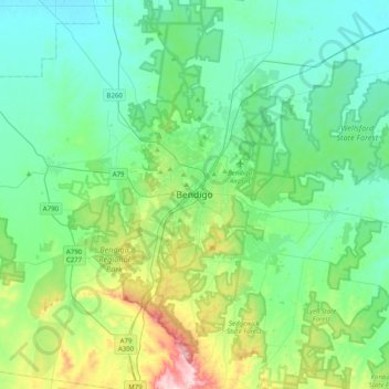
Nom : Carte topographique Bendigo, altitude, relief.
Altitude moyenne : 223 m
Altitude minimum : 139 m
Altitude maximum : 536 m
Autres cartes topographiques
Cliquez sur une carte pour visualiser sa topographie, son altitude et son relief.
Wilsons Promontory
Wilsons Promontory, Shire of South Gippsland, Victoria, 3960, Australie
Altitude moyenne : 38 m
Melbourne Water Pipe Reserve
Australie > Victoria > Melbourne
Melbourne Water Pipe Reserve, Nunawading, Melbourne, City of Whitehorse, Victoria, Australie
Altitude moyenne : 133 m
Melbourne-Sud
Australie > Victoria > Melbourne
Melbourne-Sud, Melbourne, City of Port Phillip, Victoria, 3205, Australie
Altitude moyenne : 9 m
Mount Napier
Mount Napier, Shire of Southern Grampians, Victoria, Australie
Altitude moyenne : 213 m
Burwood District
Australie > Victoria > Melbourne > Burwood
Burwood District, Burwood, Melbourne, City of Whitehorse, Victoria, 3125, Australie
Altitude moyenne : 73 m
Melbourne District
Australie > Victoria > Melbourne
Melbourne District, Melbourne, City of Melbourne, Victoria, Australie
Altitude moyenne : 20 m
Shire of South Gippsland
Shire of South Gippsland, Victoria, Australie
Altitude moyenne : 81 m
Bacchus Marsh
Australie > Victoria > Bacchus Marsh
Bacchus Marsh, Shire of Moorabool, Victoria, 3340, Australie
Altitude moyenne : 133 m
Shire of Yarra Ranges
Shire of Yarra Ranges, Victoria, Australie
Altitude moyenne : 440 m
St Andrews Beach
St Andrews Beach, Shire of Mornington Peninsula, Victoria, Australie
Altitude moyenne : 10 m
Tidal River
Tidal River, Shire of South Gippsland, Victoria, Australie
Altitude moyenne : 146 m
Shire of Mornington Peninsula
Shire of Mornington Peninsula, Victoria, Australie
Altitude moyenne : 23 m
Falls Creek
Australie > Victoria > Falls Creek Alpine Resort
Falls Creek, Falls Creek Alpine Resort, Victoria, 3699, Australie
Altitude moyenne : 1 459 m
Mornington
Australie > Victoria > Mornington
Mornington, Shire of Mornington Peninsula, Victoria, 3931, Australie
Altitude moyenne : 44 m
Grampians NP
Grampians NP, Glenelg River Road, Halls Gap, Shire of Southern Grampians, Grampians, Victoria, Australie
Altitude moyenne : 262 m
City of Boroondara
City of Boroondara, Victoria, Australie
Altitude moyenne : 53 m
Triplet Falls
Triplet Falls, Shire of Colac Otway, Barwon South West, Victoria, Australie
Altitude moyenne : 366 m
Cook Creek
Cook Creek, Shire of Hepburn, Grampians, Victoria, Australie
Altitude moyenne : 339 m
Great Otway National Park
Australie > Victoria > Forrest
Great Otway National Park, Kaanglang Road, Forrest, Shire of Colac Otway, Barwon South West, Victoria, 3236, Australie
Altitude moyenne : 111 m
Nigretta Falls
Nigretta Falls, Shire of Southern Grampians, Barwon South West, Victoria, Australie
Altitude moyenne : 171 m
Cape Schanck
Cape Schanck, Shire of Mornington Peninsula, Victoria, Australie
Altitude moyenne : 83 m
Mornington District
Australie > Victoria > Melbourne
Mornington District, Melbourne, Shire of Mornington Peninsula, Victoria, Australie
Altitude moyenne : 50 m
Shire of Corangamite
Shire of Corangamite, Victoria, Australie
Altitude moyenne : 151 m
Mount Sunday
Mount Sunday, Shire of Mansfield, Hume, Victoria, Australie
Altitude moyenne : 1 141 m
Pentland Hills
Australie > Victoria > Pentland Hills
Pentland Hills, Shire of Moorabool, Grampians, Victoria, 3341, Australie
Altitude moyenne : 293 m
Mount Dandenong
Australie > Victoria > Montrose
Mount Dandenong, Montrose, Shire of Yarra Ranges, Victoria, 3765, Australie
Altitude moyenne : 429 m