Géolocaliser

Carte topographique Ko Pha Ngan

Carte interactive

Cliquez sur la carte pour afficher l’altitude.

À propos de cette carte

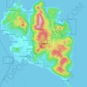
Nom : Carte topographique Ko Pha Ngan, altitude, relief.

Lieu : Ko Pha Ngan, Surat Thani Province, Thailand (9.66567 99.96074 9.80402 100.08177)

Altitude moyenne : 84 m

Altitude minimum : 0 m

Altitude maximum : 602 m

Due to its topography, the population hugs the coastline. The mountainous interior is generally inaccessible. More than half the island designated as national park and Ko Pha-ngan has more than 80 km2 (31 sq mi) of relatively unspoiled rain forest with diverse flora and fauna. It is also considered a spiritual place, with numerous Buddhist temples around the island and a thriving spa, retreat, and meditation industry.

Wikipedia (CC-BY-SA 3.0)

Autres cartes topographiques

Cliquez sur une carte pour visualiser sa topographie, son altitude et son relief.

Surat Thani

Thailand > Surat Thani Province

Surat Thani, Wat Pradu, Surat Thani Province, 84000, Thailand

Altitude moyenne : 10 m

Baan Thong Krut

Thailand > Surat Thani Province

Baan Thong Krut, Surat Thani Province, 84010, Thailand

Altitude moyenne : 38 m

Tapi River

Thailand > Surat Thani Province

Tapi River, Surat Thani Province, Thailand

Altitude moyenne : 123 m

Choeng Mon

Thailand > Surat Thani Province

Choeng Mon, Surat Thani Province, 84320, Thailand

Altitude moyenne : 15 m

Baan Chaweng Noi

Thailand > Surat Thani Province > Baan Chaweng Noi

Baan Chaweng Noi, Surat Thani Province, 84320, Thailand

Altitude moyenne : 77 m

Ao Tanote - อ่าวโตนด

Thailand > Surat Thani Province > Baan Mae Haad

Ao Tanote - อ่าวโตนด, Songserm Road, Baan Mae Haad, Surat Thani Province, 84369, Thailand

Altitude moyenne : 75 m