
Carte topographique The Municipal District of Muinebeag
Carte interactive
Cliquez sur la carte pour afficher l’altitude.
À propos de cette carte
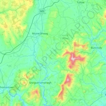
Nom : Carte topographique The Municipal District of Muinebeag, altitude, relief.
Altitude moyenne : 129 m
Altitude minimum : 1 m
Altitude maximum : 789 m
Autres cartes topographiques
Cliquez sur une carte pour visualiser sa topographie, son altitude et son relief.
Barrow
Barrow, Kyle ED, The Municipal District of Muinebeag, Comté de Carlow, Leinster, R95 C792, Irlande
Altitude moyenne : 55 m
Eaglehill Newton
Eaglehill Newton, Clonmore ED, The Municipal District of Tullow, Comté de Carlow, Leinster, Irlande
Altitude moyenne : 181 m