
Carte topographique Itapevi
Carte interactive
Cliquez sur la carte pour afficher l’altitude.
À propos de cette carte
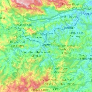
Nom : Carte topographique Itapevi, altitude, relief.
Altitude moyenne : 814 m
Altitude minimum : 721 m
Altitude maximum : 1 047 m
Autres cartes topographiques
Cliquez sur une carte pour visualiser sa topographie, son altitude et son relief.
Praça Arvers
Brésil > São Paulo > Região Metropolitana de São Paulo > São Paulo
Altitude moyenne : 772 m
Praça Mário Garnero
Brésil > São Paulo > Região Metropolitana de São Paulo > São Paulo
Altitude moyenne : 777 m
São Paulo
Brésil > São Paulo > Região Metropolitana de São Paulo > São Paulo
Située dans le Sud du Brésil dans l'État de São Paulo (SP) sur le plateau de Piratininga à 760 mètres d'altitude, São Paulo a un climat de type subtropical, avec 18,5 °C de température moyenne. La ville est traversée par deux rivières, le Rio Tietê et le Rio Pinheiros qui confluent avant de…
Altitude moyenne : 785 m
Franco da Rocha
Brésil > São Paulo > Região Metropolitana de São Paulo > Franco da Rocha
Altitude moyenne : 830 m