
Carte topographique Solwezi
Carte interactive
Cliquez sur la carte pour afficher l’altitude.
Solwezi
Solwezi est situé sur la route Chingola-Solwezi-Mwinilunga (route T5 (en)), à environ 177 km au nord-ouest de Chingola et à environ 275 km au sud-est de Mwinilunga (en), dans l'extrême nord-ouest du pays. Les coordonnées géographiques de la ville sont : 12° 08' 36" S, 26° 23' 09" E. Solwezi se trouve à une altitude moyenne de 1 397 m au-dessus du niveau de la mer.
À propos de cette carte
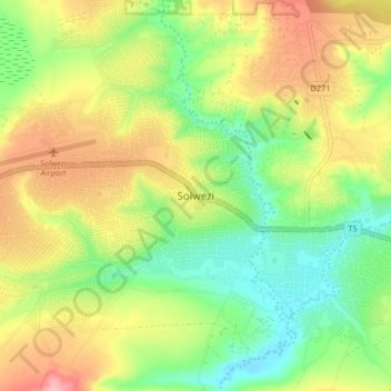
Nom : Carte topographique Solwezi, altitude, relief.
Lieu : Solwezi, Solwezi District, Province Nord-Occidentale, Zambie (-12.22206 26.35907 -12.14206 26.43907)
Altitude moyenne : 1 352 m
Altitude minimum : 1 297 m
Altitude maximum : 1 422 m