
Carte topographique Lod
Carte interactive
Cliquez sur la carte pour afficher l’altitude.
À propos de cette carte
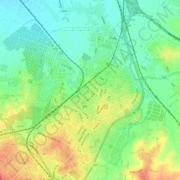
Nom : Carte topographique Lod, altitude, relief.
Lieu : Lod, נפת רמלה, District centre, 7147308, Israël (31.93243 34.86123 31.97477 34.92107)
Altitude moyenne : 59 m
Altitude minimum : 36 m
Altitude maximum : 90 m
Autres cartes topographiques
Cliquez sur une carte pour visualiser sa topographie, son altitude et son relief.
Rishon LeZion
Rishon LeZion, נפת רחובות, District centre, Israël
Altitude moyenne : 52 m
Palmachim
Israël > District centre > Conseil régional de Gan Raveh
Palmachim, Conseil régional de Gan Raveh, נפת רחובות, District centre, Israël
Altitude moyenne : 9 m
Kiryat Ekron
Kiryat Ekron, נפת רחובות, District centre, Israël
Altitude moyenne : 58 m
Petah Tikva
Israël > District centre > Petah Tikva
Petah Tikva, נפת פתח תקווה, District centre, Israël
Altitude moyenne : 37 m
Netanya
Netanya, נפת השרון, District centre, 42***, Israël
Altitude moyenne : 20 m
Yad Binyamin
Israël > District centre > נפת רחובות > Nahal Sorek > Yad Binyamin
Yad Binyamin, Nahal Sorek, נפת רחובות, District centre, Israël
Altitude moyenne : 69 m
Yama
Israël > District centre > Zemer
Yama, Zemer, נפת השרון, District centre, 3884500, Israël
Altitude moyenne : 75 m
קדימה - צורן
Israël > District centre > קדימה - צורן
קדימה - צורן, נפת השרון, District centre, Israël
Altitude moyenne : 50 m
Rosh HaAyin
Israël > District centre > Rosh HaAyin
Rosh HaAyin, נפת פתח תקווה, District centre, Israël
Altitude moyenne : 83 m