
Carte topographique העיר העתיקה
Carte interactive
Cliquez sur la carte pour afficher l’altitude.
À propos de cette carte
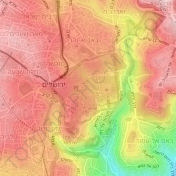
Nom : Carte topographique העיר העתיקה, altitude, relief.
Lieu : העיר העתיקה, Jérusalem, District de Jérusalem, Israël (31.77281 35.22570 31.78374 35.23756)
Altitude moyenne : 749 m
Altitude minimum : 583 m
Altitude maximum : 825 m
Autres cartes topographiques
Cliquez sur une carte pour visualiser sa topographie, son altitude et son relief.
Gerald Halbert Park & Observation Plaza
Israël > District de Jérusalem > Jérusalem
Gerald Halbert Park & Observation Plaza, Mont Scopus, Jérusalem, נפת ירושלים, District de Jérusalem, Israël
Altitude moyenne : 732 m
Golgotha
Israël > District de Jérusalem > Jérusalem
Golgotha, Bab a-Zahara, Jérusalem, נפת ירושלים, District de Jérusalem, 9100902, Israël
Altitude moyenne : 765 m
הרובע היהודי
Israël > District de Jérusalem > Jérusalem
הרובע היהודי, העיר העתיקה, Jérusalem, נפת ירושלים, District de Jérusalem, no, Israël
Altitude moyenne : 739 m