
Faire un don
Équipez-vous pour votre prochaine aventure :
En tant que Partenaire Amazon, ce site perçoit une commission sur les achats éligibles sans surcoût pour vous.
Carte topographique Toulouse
Cliquez sur la carte pour afficher l’altitude.
Faire un don
Équipez-vous pour votre prochaine aventure :
En tant que Partenaire Amazon, ce site perçoit une commission sur les achats éligibles sans surcoût pour vous.
Toulouse
La proximité géographique de Toulouse avec l'Espagne et les anciennes relations historiques entre le comté de Toulouse et le royaume d'Aragon, ont fait que de tout temps la présence d'une population espagnole à Toulouse a été sensible. En effet elle représente l'une des plus importantes communautés de la ville avec près de 20 000 à 25 000 personnes. Il suffirait pour s'en apercevoir de fréquenter quelques marchés populaires de Toulouse (Cristal, Saint-Aubin, Saint-Cyprien, Saint-Sernin…) où on ne manquera pas d'entendre parler castillan. Toulouse a d'abord vécu l'immigration de travail des années 1920 et du début des années 1930, avec des installations dans des quartiers à l'époque insalubres ou malfamés comme celui de Saint-Cyprien, puis a été la principale destination de l'exil républicain espagnol dans les années 1930. Cependant, les Espagnols proprement dits sont aujourd'hui peu nombreux, 2 386 au recensement de 2006, soit 6,3 % seulement des étrangers de la commune. La ville a fêté en 2006 le 75e anniversaire de la république espagnole au cours duquel l'ancien maire de Toulouse, Jean-Luc Moudenc a fait un discours qui permit à de nombreux jeunes et nouveaux toulousains de comprendre l'importance de cet exil, « Oui, l'émotion rejoint ici le calendrier de la tragédie de l’Histoire, de la tragédie d’une guerre fratricide qui jeta l’une contre l'autre, l'Espagne républicaine et l'Espagne franquiste et conduisit 100 000 républicains et leurs familles à Toulouse. Toulouse qui se souvient de la nouvelle topographie politique qu’avaient inventée les partis politiques en exil, les communistes à la Bourse du travail, les anarchistes au 4 rue de Belfort et autour de la fontaine de la place Wilson, les guérilleros au café de la Paix de la place du Capitole, les socialistes au 69 rue du Taur dans la future cinémathèque, un peu tous à l’Ateneo de la rue de l’Étoile, les moins politisés à la Casa de España. ».
Faire un don
Équipez-vous pour votre prochaine aventure :
En tant que Partenaire Amazon, ce site perçoit une commission sur les achats éligibles sans surcoût pour vous.
À propos de cette carte
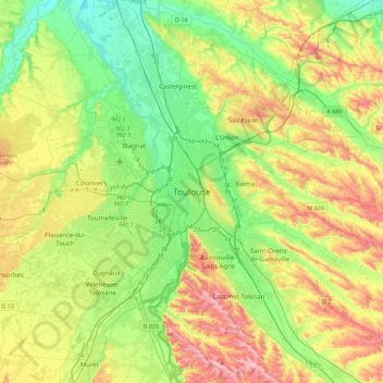
Nom : Carte topographique Toulouse, altitude, relief.
Altitude moyenne : 173 m
Altitude minimum : 104 m
Altitude maximum : 288 m
Faire un don
Équipez-vous pour votre prochaine aventure :
En tant que Partenaire Amazon, ce site perçoit une commission sur les achats éligibles sans surcoût pour vous.
Autres cartes topographiques
Cliquez sur une carte pour visualiser sa topographie, son altitude et son relief.
Cratère de l'explosion de l'usine AZF
France > Occitanie > Haute-Garonne > Toulouse
Altitude moyenne : 151 m