Géolocaliser

Carte topographique Vojvodina

Carte interactive

Cliquez sur la carte pour afficher l’altitude.

À propos de cette carte
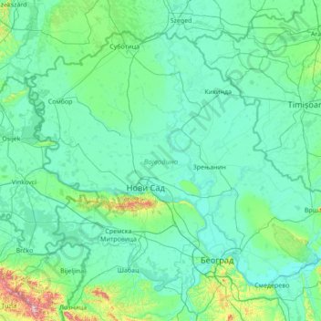
Nom : Carte topographique Vojvodina, altitude, relief.

Lieu : Vojvodina, Serbia (44.62973 18.81499 46.19028 21.56013)

Altitude moyenne : 110 m

Altitude minimum : 66 m

Altitude maximum : 860 m

Today, the western part of Syrmia is in Croatia, the northern part of Bačka is in Hungary, the eastern part of Banat is in Romania (with a small piece in Hungary), while Baranja (which is between the Danube and the Drava) is in Hungary and Croatia. Vojvodina has a total surface area of 21,500 km2 (8,300 sq mi). Vojvodina is also part of the Danube-Kris-Mures-Tisa euroregion. The Gudurica peak (Gudurički vrh) on the Vršac Mountains, is the highest peak in Vojvodina, at an altitude of 641 m above sea level.

Wikipedia (CC-BY-SA 3.0)

Autres cartes topographiques

Cliquez sur une carte pour visualiser sa topographie, son altitude et son relief.

Serbia

Serbia > Central Serbia > Kladovo Municipality

Serbia, 35, Novi Sip, Kladovo Municipality, Bor Administrative District, Central Serbia, Serbia

Altitude moyenne : 518 m

Kragujevac

Serbia > Central Serbia > Sumadija Administrative District

Kragujevac, City of Kragujevac, Sumadija Administrative District, Central Serbia, 34114, Serbia

Altitude moyenne : 320 m

Доњи Таванкут

Serbia > Vojvodina > Donji Tavankut

Доњи Таванкут, Donji Tavankut, Subotica City, North Backa Administrative District, Vojvodina, 24214, Serbia

Altitude moyenne : 123 m

Kopaonik

Serbia > Central Serbia > Kopaonik

Kopaonik, Raska Administrative District, Central Serbia, 36354, Serbia

Altitude moyenne : 1 703 m

Besna Kobila

Serbia > Central Serbia

Besna Kobila, Vranje City, Pcinja Administrative District, Central Serbia, Serbia

Altitude moyenne : 1 612 m

Zlatibor

Serbia > Central Serbia > Zlatibor

Zlatibor, Zlatibor Administrative District, Central Serbia, 31315, Serbia

Altitude moyenne : 967 m

Nisava

Serbia > Central Serbia

Nisava, Pirot Administrative District, Central Serbia, 70857, Serbia

Altitude moyenne : 703 m

Caricina

Serbia > Central Serbia > Царичина

Caricina, Царичина, Zlatibor Administrative District, Central Serbia, Serbia

Altitude moyenne : 1 345 m

City of Belgrade

Serbia > Central Serbia

City of Belgrade, Central Serbia, Serbia

Altitude moyenne : 136 m