
Carte topographique The Municipal District of Navan
Carte interactive
Cliquez sur la carte pour afficher l’altitude.
À propos de cette carte
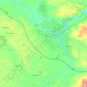
Nom : Carte topographique The Municipal District of Navan, altitude, relief.
Altitude moyenne : 62 m
Altitude minimum : 22 m
Altitude maximum : 154 m
Autres cartes topographiques
Cliquez sur une carte pour visualiser sa topographie, son altitude et son relief.
Navan
Navan, The Municipal District of Navan, Comté de Meath, Leinster, Irlande
Altitude moyenne : 52 m
Slane ED
Slane ED, The Municipal District of Laytown — Bettystown, Comté de Meath, Leinster, Irlande
Altitude moyenne : 79 m
Hill of Tara
Hill of Tara, The Municipal District of Ashbourne, Comté de Meath, Leinster, C15 NYY6, Irlande
Altitude moyenne : 106 m
The Municipal District of Ratoath
The Municipal District of Ratoath, Comté de Meath, Leinster, Irlande
Altitude moyenne : 87 m
Donore
Donore, Saint Mary's ED, The Municipal District of Laytown — Bettystown, Comté de Meath, Leinster, Irlande
Altitude moyenne : 58 m
Boyne
Boyne, Kilcooly ED, The Municipal District of Trim, Comté de Meath, Leinster, C15 X3Y2, Irlande
Altitude moyenne : 57 m
Bettystown
Bettystown, The Municipal District of Laytown — Bettystown, Comté de Meath, Leinster, A92 AH27, Irlande
Altitude moyenne : 6 m