
Carte topographique Raivavae
Carte interactive
Cliquez sur la carte pour afficher l’altitude.
Raivavae
Située à 630 km au sud-est de Tahiti, Raivavae est une île volcanique qui culmine avec le mont Hiro à 437 mètres d'altitude. Elle présente une superficie de terres émergées de 16 km2, entourées d'un lagon assez important mais plus petit que celui de Tubuai, ceinturé par une barrière de corail comprenant vingt-huit motu (îlots).
À propos de cette carte
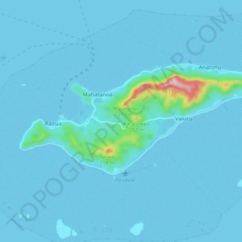
Nom : Carte topographique Raivavae, altitude, relief.
Altitude moyenne : 19 m
Altitude minimum : -1 m
Altitude maximum : 394 m