Carte topographique Lake Sevan
Carte interactive
Cliquez sur la carte pour afficher l’altitude.
À propos de cette carte
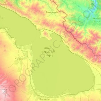
Nom : Carte topographique Lake Sevan, altitude, relief.
Lieu : Lake Sevan, Gegharkunik Province, Armenia (40.15289 44.94790 40.63202 45.64481)
Altitude moyenne : 2 025 m
Altitude minimum : 1 116 m
Altitude maximum : 3 547 m
Lake Sevan (Armenian: Սևանա լիճ, romanized: Sevana lich) is the largest body of water in both Armenia and the Caucasus region. It is one of the largest freshwater high-altitude (alpine) lakes in Eurasia. The lake is situated in Gegharkunik Province, at an altitude of 1,900 m (6,234 ft) above sea level. The total surface area of its basin is about 5,000 km2 (1,900 sq mi), which makes up 1⁄6 of Armenia's territory. The lake itself is 1,242 km2 (480 sq mi), and the volume is 32.8 km3 (7.9 cu mi). It is fed by 28 rivers and streams. Only 10% of the incoming water is drained by the Hrazdan River, while the remaining 90% evaporates.
Autres cartes topographiques
Cliquez sur une carte pour visualiser sa topographie, son altitude et son relief.
Vardenis community
Armenia > Gegharkunik Province
Vardenis community, Gegharkunik Province, Armenia
Altitude moyenne : 2 284 m
Sevan town
Armenia > Gegharkunik Province
Sevan town, Gegharkunik Province, Armenia
Altitude moyenne : 1 966 m
Akunk
Armenia > Gegharkunik Province > Akunk
Akunk, Vardenis region, Gegharkunik Province, 1601, Armenia
Altitude moyenne : 2 003 m
Chambarak
Armenia > Gegharkunik Province > Chambarak
Chambarak, Gegharkunik Province, Armenia
Altitude moyenne : 1 880 m