
Carte topographique Volcán Nevado del Ruiz
Carte interactive
Cliquez sur la carte pour afficher l’altitude.
Volcán Nevado del Ruiz
Le Nevado del Ruiz est un volcan de la cordillère des Andes, un des plus élevés de Colombie. Il culmine à 5 321 mètres d'altitude. Comme son nom l'indique, il est recouvert de glaciers, lesquels entourent le cratère Arenas et sont en phase de régression rapide. Issu d'un volcanisme de subduction, le Nevado del Ruiz a connu de fréquentes éruptions pliniennes au cours de l'Holocène. Celle de 1985 a été l'une des plus meurtrières de l'histoire en rasant notamment la ville d'Armero. En effet, le mélange de cendres et d'eau de fonte provoque régulièrement des lahars dévastateurs. Le volcan est désormais en constante observation afin de protéger au mieux les centaines de milliers de personnes vivant dans les vallées à ses pieds.
À propos de cette carte
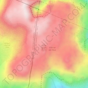
Nom : Carte topographique Volcán Nevado del Ruiz, altitude, relief.
Altitude moyenne : 5 119 m
Altitude minimum : 4 738 m
Altitude maximum : 5 286 m
Autres cartes topographiques
Cliquez sur une carte pour visualiser sa topographie, son altitude et son relief.
Cajamarca
Cajamarca a été fondée sous le nom « San Antonio de Cajamarca » et ce nom a été enregistré par les premiers chroniqueurs comme « Caxamarca », terme tiré du quechua kasha marka (en dialecte cajamarca) signifiant « peuple (marka) d'épines (kasha) » en référence à l'abondance du cactus de San…
Altitude moyenne : 2 652 m