
Carte topographique Telluride
Carte interactive
Cliquez sur la carte pour afficher l’altitude.
Telluride
Selon le recensement de 2010, Telluride compte 2 325 habitants. La municipalité s'étend sur 0,74 milles carrés (1,92 km2). À une altitude de 2 667 mètres, la ville est également connue pour sa station de ski et ses pistes durant l'hiver, ainsi que pour son festival de cinéma.
À propos de cette carte
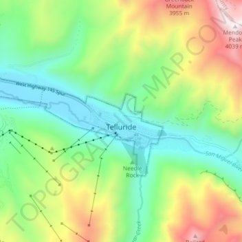
Nom : Carte topographique Telluride, altitude, relief.
Altitude moyenne : 3 125 m
Altitude minimum : 2 647 m
Altitude maximum : 4 023 m