Carte topographique Buzău
Carte interactive
Cliquez sur la carte pour afficher l’altitude.
À propos de cette carte
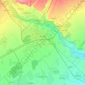
Nom : Carte topographique Buzău, altitude, relief.
Lieu : Buzău, Romania (45.09161 26.71469 45.18375 26.92587)
Altitude moyenne : 96 m
Altitude minimum : 66 m
Altitude maximum : 152 m
The city is located in the center of the county, 100 km north-east of Bucharest, in the South-East of Romania, taking up a total area of 81,3 km2, at the outermost curvature of the Subcarpathian foothills, at the crossroads of the three main Romanian historical provinces: Wallachia, Transylvania and Moldavia. It is entirely placed on the right bank of Buzău river, which forms its northern limit. The shape of the city is oblong, longer along the river and shorter across. It reaches altitudes of 101 meters in the North-West, near the foothills, going down to 88 meters on the river bank, while the average altitude of 95 meters is the same as the altitude of Dacia square, in the city center. Thus, Buzău is placed in a flat area, with a height difference of just 10 meters along a 4 kilometer line.
Autres cartes topographiques
Cliquez sur une carte pour visualiser sa topographie, son altitude et son relief.
Penteleu
Romania > Buzău > Gura Teghii
Penteleu, Gura Teghii, Buzău, Romania
Altitude moyenne : 1 486 m
Bâsca Chiojdului
Bâsca Chiojdului, Chiojdu, Buzău, 127171, Romania
Altitude moyenne : 732 m
Vadu Oii
Romania > Buzău > Gura Teghii
Vadu Oii, Gura Teghii, Buzău, 127286, Romania
Altitude moyenne : 819 m