
Carte topographique Saint-Andréasberg
Carte interactive
Cliquez sur la carte pour afficher l’altitude.
Saint-Andréasberg
Du fait de son altitude, Saint-Andréasberg (520–720 m) et Sonnenberg (800–850 m) disposent d'un niveau d'enneigement encore relativement sûr. Saint-Andréasberg est un centre de ski alpin du Harz, avec trois téléskis sur le Sonnenberg, ainsi que deux télésièges deux-places et trois téléskis à la station de ski de Matthias-Schmidt-Berg, laquelle accueille également une piste de luge d'été. La première piste de Snowtubing du Harz se situe dans la vallée Teichtal. La réseau de ski de fond autour de Saint-Andréasberg compte 40 km de pistes et est relié au niveau du Sonnenberg avec Oderbrück/Torfhaus et la piste de Ackerloipe/Altenau. La marche nordique, la randonnée pédestre, le VTT et le trekking sont des sports très appréciés dans les environs calmes de la ville montagnarde. Un parcours acrobatique en hauteur a été aménagé dans le parc. Le lac Oderteich, situé dans le Parc national du Harz, permet de s'y baigner en été dans sa partie sud.
À propos de cette carte
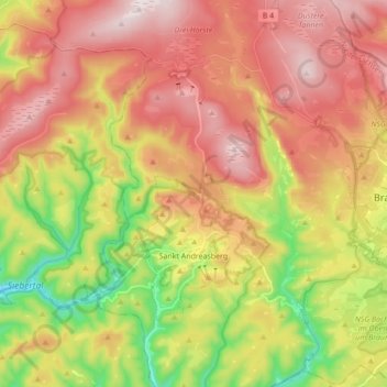
Nom : Carte topographique Saint-Andréasberg, altitude, relief.
Altitude moyenne : 648 m
Altitude minimum : 347 m
Altitude maximum : 914 m