
Faire un don
Équipez-vous pour votre prochaine aventure :
En tant que Partenaire Amazon, ce site perçoit une commission sur les achats éligibles sans surcoût pour vous.
Carte topographique Show Low
Cliquez sur la carte pour afficher l’altitude.
Faire un don
Équipez-vous pour votre prochaine aventure :
En tant que Partenaire Amazon, ce site perçoit une commission sur les achats éligibles sans surcoût pour vous.
À propos de cette carte
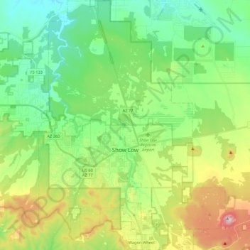
Nom : Carte topographique Show Low, altitude, relief.
Altitude moyenne : 1 957 m
Altitude minimum : 1 794 m
Altitude maximum : 2 309 m
Faire un don
Équipez-vous pour votre prochaine aventure :
En tant que Partenaire Amazon, ce site perçoit une commission sur les achats éligibles sans surcoût pour vous.
Autres cartes topographiques
Cliquez sur une carte pour visualiser sa topographie, son altitude et son relief.
Monument Valley Navajo Tribal Park
États-Unis d'Amérique > Arizona > Navajo County
Monument Valley connaît un climat désertique avec des hivers froids et des étés chauds. Ces derniers sont toutefois tempérés par l'altitude de la région : alors que la température excède 32 °C durant 54 jours en moyenne par an, elle dépasse rarement 38 °C sur les hauteurs. Les nuits sont fraîches,…
Altitude moyenne : 1 675 m
Monument Valley Navajo Tribal Park
États-Unis d'Amérique > Arizona > Navajo County
Monument Valley connaît un climat désertique avec des hivers froids et des étés chauds. Ces derniers sont toutefois tempérés par l'altitude de la région : alors que la température excède 32 °C durant 54 jours en moyenne par an, elle dépasse rarement 38 °C sur les hauteurs. Les nuits sont fraîches,…
Altitude moyenne : 1 620 m
Faire un don
Équipez-vous pour votre prochaine aventure :
En tant que Partenaire Amazon, ce site perçoit une commission sur les achats éligibles sans surcoût pour vous.