Géolocaliser

Carte topographique Bibury

Carte interactive

Cliquez sur la carte pour afficher l’altitude.

À propos de cette carte

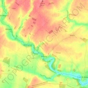
Nom : Carte topographique Bibury, altitude, relief.

Lieu : Bibury, Cotswold District, Gloucestershire, England, United Kingdom (51.73942 -1.86928 51.79538 -1.78876)

Altitude moyenne : 135 m

Altitude minimum : 94 m

Altitude maximum : 163 m

The parish is approximately rectangular and stretches far to the rolling, elevated, north. It includes on outlying settlement, Ablington, in the upper valley. Bibury Farm is 300 metres (330 yd) from the village, 151 metres (495 ft) above Ordnance Datum (AOD), which is a similar elevation to much of the north. The south rises to a maximum of 141 metres (463 ft) on its periphery along Akeman Street, a Roman road, before ascending further in other more distant lands. The valley floor within the Bibury boundary, northwest and southeast, ranges from 108 to 98 metres (354 to 322 ft) AOD.

Wikipedia (CC-BY-SA 3.0)

Autres cartes topographiques

Cliquez sur une carte pour visualiser sa topographie, son altitude et son relief.

Cutsdean

United Kingdom > England > Gloucestershire > Cotswold District

Cutsdean, Cotswold District, Gloucestershire, England, United Kingdom

Altitude moyenne : 233 m

Dowdeswell

United Kingdom > England > Gloucestershire > Cotswold District

Dowdeswell, Cotswold District, Gloucestershire, England, United Kingdom

Altitude moyenne : 209 m

Daylesford

United Kingdom > England > Gloucestershire > Cotswold District

Daylesford, Cotswold District, Gloucestershire, England, GL56 0YG, United Kingdom

Altitude moyenne : 137 m

Barnsley

United Kingdom > England > Gloucestershire > Cotswold District

Barnsley, Cotswold District, Gloucestershire, England, GL7 5EF, United Kingdom

Altitude moyenne : 135 m

Maugersbury

United Kingdom > England > Gloucestershire > Cotswold District

Maugersbury, Cotswold District, Gloucestershire, England, GL54 1HR, United Kingdom

Altitude moyenne : 166 m

Duntisbourne Abbots

United Kingdom > England > Gloucestershire > Cotswold District

Duntisbourne Abbots, Cotswold District, Gloucestershire, England, GL7 7JN, United Kingdom

Altitude moyenne : 204 m

Tarlton

United Kingdom > England > Gloucestershire > Cotswold District

Tarlton, Rodmarton, Cotswold District, Gloucestershire, England, GL7 6PA, United Kingdom

Altitude moyenne : 144 m

Bagpath

United Kingdom > England > Gloucestershire > Cotswold District

Bagpath, Kingscote, Cotswold District, Gloucestershire, England, GL8 8YG, United Kingdom

Altitude moyenne : 198 m

Cerney Wick

United Kingdom > England > Gloucestershire > Cotswold District

Cerney Wick, Cotswold District, Gloucestershire, England, GL7 5QH, United Kingdom

Altitude moyenne : 85 m

Birdlip

United Kingdom > England > Gloucestershire > Cotswold District

Birdlip, Cotswold District, Gloucestershire, England, United Kingdom

Altitude moyenne : 261 m

Worcestershire (detached)

United Kingdom > England > Gloucestershire > Cotswold District

Worcestershire (detached), Cotswold District, Gloucestershire, West Midlands Combined Authority, England, United Kingdom

Altitude moyenne : 103 m

Syde

United Kingdom > England > Gloucestershire > Cotswold District

Syde, Cotswold District, Gloucestershire, England, GL53 9PN, United Kingdom

Altitude moyenne : 238 m

Mickleton

United Kingdom > England > Gloucestershire > Cotswold District

Mickleton, Cotswold District, Gloucestershire, England, GL55 6TS, United Kingdom

Altitude moyenne : 101 m

Taylors Hill

United Kingdom > England > Gloucestershire > Cotswold District

Taylors Hill, Cotswold District, Gloucestershire, England, GL54 4BJ, United Kingdom

Altitude moyenne : 237 m

Cirencester

United Kingdom > England > Gloucestershire > Cotswold District > Chesterton

Cirencester, Chesterton, Cotswold District, Gloucestershire, England, United Kingdom

Altitude moyenne : 128 m

Trewsbury Mead

United Kingdom > England > Gloucestershire > Cotswold District

Trewsbury Mead, Coates, Cotswold District, Gloucestershire, England, GL7 6NY, United Kingdom

Altitude moyenne : 122 m

North Cerney

United Kingdom > England > Gloucestershire > Cotswold District

North Cerney, Cotswold District, Gloucestershire, England, GL7 7BZ, United Kingdom

Altitude moyenne : 179 m

Hatherop

United Kingdom > England > Gloucestershire > Cotswold District

Hatherop, Cotswold District, Gloucestershire, England, GL7 3NA, United Kingdom

Altitude moyenne : 120 m

Stow-on-the-Wold

United Kingdom > England > Gloucestershire > Cotswold District

Stow-on-the-Wold, Cotswold District, Gloucestershire, England, GL54 1AB, United Kingdom

Altitude moyenne : 163 m

Botany Bay Wood

United Kingdom > England > Gloucestershire > Cotswold District > Stow-on-the-Wold

Botany Bay Wood, Maugersbury, Stow-on-the-Wold, Cotswold District, Gloucestershire, England, United Kingdom

Altitude moyenne : 171 m

Eastleach Martin

United Kingdom > England > Gloucestershire > Cotswold District > Eastleach Turville

Eastleach Martin, Eastleach, Eastleach Turville, Cotswold District, Gloucestershire, England, GL7 3NW, United Kingdom

Altitude moyenne : 111 m

Saintbury

United Kingdom > England > Gloucestershire > Cotswold District

Saintbury, Cotswold District, Gloucestershire, England, WR12 7PX, United Kingdom

Altitude moyenne : 124 m

Coberley

United Kingdom > England > Gloucestershire > Cotswold District

Coberley, Cotswold District, Gloucestershire, England, GL53 9QZ, United Kingdom

Altitude moyenne : 240 m

Somerford Keynes

United Kingdom > England > Gloucestershire > Cotswold District

Somerford Keynes, Cotswold District, Gloucestershire, England, GL7 6DR, United Kingdom

Altitude moyenne : 91 m

Lechlade

United Kingdom > England > Gloucestershire > Cotswold District

Lechlade, Cotswold District, Gloucestershire, England, GL7 3BY, United Kingdom

Altitude moyenne : 81 m

Chipping Campden

United Kingdom > England > Gloucestershire > Cotswold District

Chipping Campden, Cotswold District, Gloucestershire, England, United Kingdom

Altitude moyenne : 191 m

Naunton

United Kingdom > England > Gloucestershire > Cotswold District

Naunton, Cotswold District, Gloucestershire, England, GL54 3AS, United Kingdom

Altitude moyenne : 201 m

Knap House Quarry, Birdlip

United Kingdom > England > Gloucestershire > Cotswold District > Birdlip

Knap House Quarry, Birdlip, Cowley, Birdlip, Cotswold District, Gloucestershire, England, United Kingdom

Altitude moyenne : 222 m

Withington

United Kingdom > England > Gloucestershire > Cotswold District

Withington, Cotswold District, Gloucestershire, England, United Kingdom

Altitude moyenne : 212 m

Down Ampney

United Kingdom > England > Gloucestershire > Cotswold District

Down Ampney, Cotswold District, Gloucestershire, England, GL7 5QR, United Kingdom

Altitude moyenne : 85 m

South Cerney

United Kingdom > England > Gloucestershire > Cotswold District > South Cerney

South Cerney, Cotswold District, Gloucestershire, England, United Kingdom

Altitude moyenne : 93 m

Weston-sub-Edge

United Kingdom > England > Gloucestershire > Cotswold District

Weston-sub-Edge, Cotswold District, Gloucestershire, England, GL55 6QZ, United Kingdom

Altitude moyenne : 98 m

Compton Abdale

United Kingdom > England > Gloucestershire > Cotswold District

Compton Abdale, Cotswold District, Gloucestershire, England, GL54 4DS, United Kingdom

Altitude moyenne : 212 m

Broad Campden

United Kingdom > England > Gloucestershire > Cotswold District

Broad Campden, Cotswold District, Gloucestershire, England, GL55 6UU, United Kingdom

Altitude moyenne : 167 m

Paxford

United Kingdom > England > Gloucestershire > Cotswold District > Paxford

Paxford, Cotswold District, Gloucestershire, England, GL55 6XW, United Kingdom

Altitude moyenne : 124 m

Upper Oddington

United Kingdom > England > Gloucestershire > Cotswold District

Upper Oddington, Cotswold District, Gloucestershire, England, GL56 0XH, United Kingdom

Altitude moyenne : 134 m

Tetbury

United Kingdom > England > Gloucestershire > Cotswold District

Tetbury, Cotswold District, Gloucestershire, England, United Kingdom

Altitude moyenne : 122 m

Winstone

United Kingdom > England > Gloucestershire > Cotswold District > Winstone

Winstone, Cotswold District, Gloucestershire, England, GL7 7JX, United Kingdom

Altitude moyenne : 222 m

Ampney Crucis

United Kingdom > England > Gloucestershire > Cotswold District

Ampney Crucis, Cotswold District, Gloucestershire, England, GL7 5SD, United Kingdom

Altitude moyenne : 114 m

Moreton-in-Marsh

United Kingdom > England > Gloucestershire > Cotswold District

Moreton-in-Marsh, Cotswold District, Gloucestershire, England, United Kingdom

Altitude moyenne : 135 m

Shorncote

United Kingdom > England > Gloucestershire > Cotswold District

Shorncote, Somerford Keynes, Cotswold District, Gloucestershire, England, GL7 6DE, United Kingdom

Altitude moyenne : 96 m

Aldsworth

United Kingdom > England > Gloucestershire > Cotswold District

Aldsworth, Cotswold District, Gloucestershire, England, GL54 3QX, United Kingdom

Altitude moyenne : 142 m

Bledington

United Kingdom > England > Gloucestershire > Cotswold District > Bledington

Bledington, Cotswold District, Gloucestershire, South West England, England, OX7 6XQ, United Kingdom

Altitude moyenne : 118 m

Fairford

United Kingdom > England > Gloucestershire > Cotswold District

Fairford, Cotswold District, Gloucestershire, England, United Kingdom

Altitude moyenne : 98 m

Northleach

United Kingdom > England > Gloucestershire > Cotswold District

Northleach, Cotswold District, Gloucestershire, England, GL54 3EE, United Kingdom

Altitude moyenne : 179 m

Ablington

United Kingdom > England > Gloucestershire > Cotswold District > Ablington

Ablington, Cotswold District, Gloucestershire, South West England, England, GL7 5NY, United Kingdom

Altitude moyenne : 136 m

Meysey Hampton

United Kingdom > England > Gloucestershire > Cotswold District > Meysey Hampton

Meysey Hampton, Cotswold District, Gloucestershire, South West England, England, GL7 5JT, United Kingdom

Altitude moyenne : 96 m

Cold Aston

United Kingdom > England > Gloucestershire > Cotswold District

Cold Aston, Cotswold District, Gloucestershire, England, GL54 3BN, United Kingdom

Altitude moyenne : 197 m

Blockley

United Kingdom > England > Gloucestershire > Cotswold District

Blockley, Cotswold District, Gloucestershire, England, United Kingdom

Altitude moyenne : 163 m

Ebrington

United Kingdom > England > Gloucestershire > Cotswold District

Ebrington, Cotswold District, Gloucestershire, England, United Kingdom

Altitude moyenne : 141 m