
Carte topographique Decatur
Carte interactive
Cliquez sur la carte pour afficher l’altitude.
À propos de cette carte
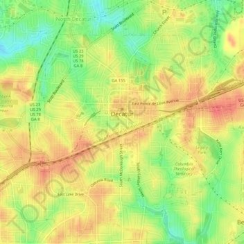
Nom : Carte topographique Decatur, altitude, relief.
Lieu : Decatur, DeKalb County, Georgia, United States (33.75097 -84.31577 33.79365 -84.27583)
Altitude moyenne : 308 m
Altitude minimum : 275 m
Altitude maximum : 332 m
Autres cartes topographiques
Cliquez sur une carte pour visualiser sa topographie, son altitude et son relief.
Stone Mountain
United States > Georgia > DeKalb County
Stone Mountain, DeKalb County, Georgia, 30087, United States
Altitude moyenne : 299 m
Mason Mill Park
United States > Georgia > DeKalb County > North Druid Hills
Mason Mill Park, North Druid Hills, DeKalb County, Georgia, 30322, United States
Altitude moyenne : 294 m
Habersham
United States > Georgia > DeKalb County
Habersham, DeKalb County, Georgia, 30340, United States
Altitude moyenne : 305 m
North Druid Hills
United States > Georgia > DeKalb County
North Druid Hills, DeKalb County, Georgia, 30329, United States
Altitude moyenne : 291 m
Tucker
United States > Georgia > DeKalb County
Tucker, DeKalb County, Georgia, 30084, United States
Altitude moyenne : 307 m
North Decatur
United States > Georgia > DeKalb County
North Decatur, DeKalb County, Georgia, 30322, United States
Altitude moyenne : 296 m
Candler-McAfee
United States > Georgia > DeKalb County
Candler-McAfee, DeKalb County, Georgia, 30032, United States
Altitude moyenne : 288 m
Dunwoody
United States > Georgia > DeKalb County
Dunwoody, DeKalb County, Georgia, United States
Altitude moyenne : 313 m
Pine Lake
United States > Georgia > DeKalb County
Pine Lake, DeKalb County, Georgia, 30072, United States
Altitude moyenne : 298 m
Windwood
United States > Georgia > DeKalb County > Dunwoody
Windwood, Dunwoody, DeKalb County, Georgia, 30360, United States
Altitude moyenne : 307 m
Brookhaven
United States > Georgia > DeKalb County
Brookhaven, DeKalb County, Georgia, United States
Altitude moyenne : 293 m
Avondale Estates
United States > Georgia > DeKalb County
Avondale Estates, DeKalb County, Georgia, United States
Altitude moyenne : 313 m
Stonecrest
United States > Georgia > DeKalb County
Stonecrest, DeKalb County, Georgia, United States
Altitude moyenne : 258 m
Scottdale
United States > Georgia > DeKalb County
Scottdale, DeKalb County, Georgia, 30079, United States
Altitude moyenne : 302 m
Dunwoody
United States > Georgia > DeKalb County > Dunwoody
Dunwoody, DeKalb County, Georgia, 30338, United States
Altitude moyenne : 309 m
Doraville
United States > Georgia > DeKalb County
Doraville, DeKalb County, Georgia, 30063, United States
Altitude moyenne : 307 m
Chamblee
United States > Georgia > DeKalb County
Chamblee, DeKalb County, Georgia, 30341, United States
Altitude moyenne : 297 m
Candler Lake
United States > Georgia > DeKalb County > North Decatur
Candler Lake, North Decatur, DeKalb County, Georgia, United States
Altitude moyenne : 290 m
Henrico
United States > Georgia > DeKalb County > Henrico
Henrico, DeKalb County, Georgia, 30288, United States
Altitude moyenne : 269 m
WSB-FM (Atlanta)
United States > Georgia > DeKalb County > Atlanta
WSB-FM (Atlanta), New Street Northeast, Candler Park, Atlanta, DeKalb County, Georgia, 30307, United States
Altitude moyenne : 307 m
Tucker
United States > Georgia > DeKalb County > Tucker
Tucker, DeKalb County, Georgia, 30084, United States
Altitude moyenne : 317 m
Redan
United States > Georgia > DeKalb County
Redan, DeKalb County, Georgia, 30088, United States
Altitude moyenne : 283 m
Clarkston
United States > Georgia > DeKalb County
Clarkston, DeKalb County, Georgia, 30021, United States
Altitude moyenne : 307 m
Lithonia
United States > Georgia > DeKalb County
Lithonia, DeKalb County, Georgia, United States
Altitude moyenne : 279 m
Belvedere Park
United States > Georgia > DeKalb County
Belvedere Park, DeKalb County, Georgia, 30032, United States
Altitude moyenne : 297 m