
Carte topographique Wards Island
Carte interactive
Cliquez sur la carte pour afficher l’altitude.
À propos de cette carte
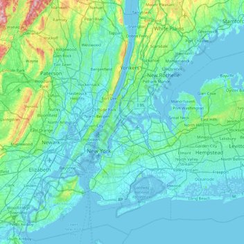
Nom : Carte topographique Wards Island, altitude, relief.
Altitude moyenne : 35 m
Altitude minimum : -6 m
Altitude maximum : 350 m
Autres cartes topographiques
Cliquez sur une carte pour visualiser sa topographie, son altitude et son relief.
Liberty Island
United States of America > New York > New York
Liberty Island, Manhattan Community Board 1, Manhattan, New York County, New York, Stone Street Historic District, New York, United States of America
Altitude moyenne : 0 m
Todt Hill
United States of America > New York > New York
Todt Hill, Staten Island, New York, Richmond County, New York, 10304, United States of America
Altitude moyenne : 75 m
Manhattan
United States of America > New York > New York
Chinatown, Manhattan Community Board 2, Manhattan, New York County, New York, United States of America
Altitude moyenne : 12 m