
Carte topographique Waukegan
Carte interactive
Cliquez sur la carte pour afficher l’altitude.
À propos de cette carte
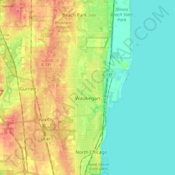
Nom : Carte topographique Waukegan, altitude, relief.
Lieu : Waukegan, Lake County, Illinois, United States (42.30938 -87.96442 42.43266 -87.80421)
Altitude moyenne : 197 m
Altitude minimum : 172 m
Altitude maximum : 236 m
Waukegan is located at 42°22′13″N 87°52′16″W / 42.37028°N 87.87111°W / 42.37028; -87.87111 (42.3703140, -87.8711404). Waukegan is on the shore of Lake Michigan, about 11 miles (18 km) south of the border with Wisconsin and 35 miles (56 km) north of downtown Chicago, at an elevation of about 715 feet (218 m) above sea level.