
Carte topographique Fenland
Carte interactive
Cliquez sur la carte pour afficher l’altitude.
À propos de cette carte
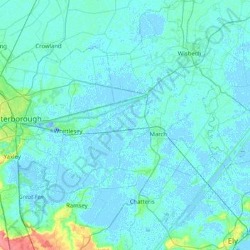
Nom : Carte topographique Fenland, altitude, relief.
Altitude moyenne : 4 m
Altitude minimum : -18 m
Altitude maximum : 54 m
Autres cartes topographiques
Cliquez sur une carte pour visualiser sa topographie, son altitude et son relief.
Wisbech St. Mary
United Kingdom > England > Cambridgeshire > Fenland > Murrow
Wisbech St. Mary, Murrow, Fenland, Cambridgeshire, East of England, England, United Kingdom
Altitude moyenne : 1 m
Wisbech and Upwell Tramway
United Kingdom > England > Cambridgeshire > Fenland > Friday Bridge
Wisbech and Upwell Tramway, March Road, Elm, Friday Bridge, Fenland, Cambridgeshire, East of England, England, PE14 0HF, United Kingdom
Altitude moyenne : 3 m