
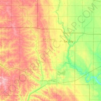
Carte topographique Sac County
Carte interactive
Cliquez sur la carte pour afficher l’altitude.
À propos de cette carte
Nom : Carte topographique Sac County, altitude, relief.
Lieu : Sac County, Iowa, United States (42.20955 -95.38837 42.56109 -94.85748)
Altitude moyenne : 397 m
Altitude minimum : 335 m
Altitude maximum : 472 m
Autres cartes topographiques
Cliquez sur une carte pour visualiser sa topographie, son altitude et son relief.
Kiron
United States > Iowa > Crawford County
Kiron, Crawford County, Iowa, United States
Altitude moyenne : 412 m
Sioux City
United States > Iowa > Woodbury County
Sioux City, Woodbury County, Iowa, United States
Altitude moyenne : 352 m
LaMotte Recreational Park
United States > Iowa > Jackson County > La Motte
LaMotte Recreational Park, La Motte, Jackson County, Iowa, United States
Altitude moyenne : 295 m
Alta Vista
United States > Iowa > Chickasaw County
Alta Vista, Chickasaw County, Iowa, United States
Altitude moyenne : 360 m
Moravia
United States > Iowa > Appanoose County
Moravia, Appanoose County, Iowa, United States
Altitude moyenne : 300 m
Maxwell
United States > Iowa > Story County
Maxwell, Story County, Iowa, United States
Altitude moyenne : 274 m
Redfield
United States > Iowa > Dallas County
Redfield, Dallas County, Iowa, United States
Altitude moyenne : 298 m
Gowrie
United States > Iowa > Webster County
Gowrie, Webster County, Iowa, United States
Altitude moyenne : 347 m
Adel
United States > Iowa > Dallas County
Adel, Dallas County, Iowa, United States
Altitude moyenne : 292 m
Cairo
United States > Iowa > Louisa County
Cairo, Louisa County, Iowa, United States
Altitude moyenne : 212 m
Catfish Creek
United States > Iowa > Dubuque County > Dubuque
Catfish Creek, Dubuque, Dubuque County, Iowa, United States
Altitude moyenne : 257 m
Rose Hill
United States > Iowa > Mahaska County
Rose Hill, Mahaska County, Iowa, United States
Altitude moyenne : 238 m
Cushing
United States > Iowa > Woodbury County
Cushing, Woodbury County, Iowa, United States
Altitude moyenne : 402 m
Johnson County
United States > Iowa > Johnson County
Johnson County, Iowa, United States
Altitude moyenne : 226 m
Dyersville
United States > Iowa > Dubuque County
Dyersville, Dubuque County, Iowa, 52040, United States
Altitude moyenne : 307 m
Hillsboro
United States > Iowa > Henry County
Hillsboro, Henry County, Iowa, United States
Altitude moyenne : 219 m
Loveland
United States > Iowa > Pottawattamie County
Loveland, Pottawattamie County, Iowa, United States
Altitude moyenne : 330 m
Dysart
United States > Iowa > Tama County
Dysart, Tama County, Iowa, United States
Altitude moyenne : 293 m
Centerville
United States > Iowa > Appanoose County
Centerville, Appanoose County, Iowa, 52544, United States
Altitude moyenne : 293 m
Hanson Lake
United States > Iowa > Black Hawk County > Evansdale
Hanson Lake, Evansdale, Black Hawk County, Iowa, United States
Altitude moyenne : 258 m
Blanchard
United States > Iowa > Page County
Blanchard, Page County, Iowa, United States
Altitude moyenne : 305 m
Waukee
United States > Iowa > Dallas County
Waukee, Dallas County, Iowa, 50263, United States
Altitude moyenne : 298 m
Westgate
United States > Iowa > Fayette County
Westgate, Fayette County, Iowa, United States
Altitude moyenne : 333 m
Holy Cross
United States > Iowa > Dubuque County
Holy Cross, Dubuque County, Iowa, United States
Altitude moyenne : 355 m
Charles City
United States > Iowa > Floyd County
Charles City, Floyd County, Iowa, 50616, United States
Altitude moyenne : 315 m
Panorama Park
United States > Iowa > Scott County > Pleasant Valley Township
Panorama Park, Pleasant Valley Township, Scott County, Iowa, United States
Altitude moyenne : 190 m
Ridgeway
United States > Iowa > Winneshiek County
Ridgeway, Winneshiek County, Iowa, United States
Altitude moyenne : 364 m
Davenport
United States > Iowa > Scott County
Davenport, Scott County, Iowa, United States
Altitude moyenne : 205 m
Berkley
United States > Iowa > Boone County
Berkley, Boone County, Iowa, United States
Altitude moyenne : 301 m
Grand River
United States > Iowa > Decatur County
Grand River, Decatur County, Iowa, United States
Altitude moyenne : 313 m
Stephenson Park
United States > Iowa > Henry County > Lowell
Stephenson Park, Lowell, Henry County, Iowa, United States
Altitude moyenne : 189 m
Hills
United States > Iowa > Johnson County
Hills, Johnson County, Iowa, 52235, United States
Altitude moyenne : 196 m
St. Olaf
United States > Iowa > Clayton County
St. Olaf, Clayton County, Iowa, United States
Altitude moyenne : 282 m
Calmar
United States > Iowa > Winneshiek County
Calmar, Winneshiek County, Iowa, United States
Altitude moyenne : 376 m
Riverton
United States > Iowa > Fremont County
Riverton, Fremont County, Iowa, United States
Altitude moyenne : 292 m
Pioneer
United States > Iowa > Humboldt County
Pioneer, Humboldt County, Iowa, United States
Altitude moyenne : 361 m
Unionville
United States > Iowa > Appanoose County > Unionville
Unionville, Appanoose County, Iowa, United States
Altitude moyenne : 284 m
Norwalk
United States > Iowa > Warren County
Norwalk, Warren County, Iowa, 50211, United States
Altitude moyenne : 271 m
Denver
United States > Iowa > Bremer County
Denver, Bremer County, Iowa, 50622, United States
Altitude moyenne : 298 m
Hills
United States > Iowa > Johnson County > Hills > Hills
Hills, Johnson County, Iowa, 52235, United States
Altitude moyenne : 196 m