
Carte topographique Riverdale Park
Carte interactive
Cliquez sur la carte pour afficher l’altitude.
À propos de cette carte
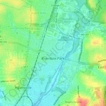
Nom : Carte topographique Riverdale Park, altitude, relief.
Altitude moyenne : 23 m
Altitude minimum : 3 m
Altitude maximum : 61 m
Autres cartes topographiques
Cliquez sur une carte pour visualiser sa topographie, son altitude et son relief.
Hyattsville
United States > Maryland > Prince George's County
Hyattsville, Prince George's County, Maryland, 20781, United States
Altitude moyenne : 61 m
College Park
United States > Maryland > Prince George's County
College Park, Prince George's County, Maryland, United States
Altitude moyenne : 38 m
North Brentwood
United States > Maryland > Prince George's County
North Brentwood, Prince George's County, Maryland, United States
Altitude moyenne : 15 m
Cottage City
United States > Maryland > Prince George's County
Cottage City, Prince George's County, Maryland, United States
Altitude moyenne : 17 m
Dinosaur Park
United States > Maryland > Prince George's County > South Laurel > Montpelier Forest
Dinosaur Park, Montpelier Forest, South Laurel, Prince George's County, Maryland, 20708, United States
Altitude moyenne : 67 m
Ammendale
United States > Maryland > Prince George's County > Konterra
Ammendale, Konterra, Prince George's County, Maryland, 20705, United States
Altitude moyenne : 56 m
North Keys
United States > Maryland > Prince George's County
North Keys, Prince George's County, Maryland, United States
Altitude moyenne : 43 m
Landover
United States > Maryland > Prince George's County > Landover
Landover, Prince George's County, Maryland, 20785, United States
Altitude moyenne : 38 m
Queenland
United States > Maryland > Prince George's County > Mellwood
Queenland, Mellwood, Prince George's County, Maryland, 20772, United States
Altitude moyenne : 42 m
Cedarville
United States > Maryland > Prince George's County
Cedarville, Prince George's County, Maryland, United States
Altitude moyenne : 63 m
Westphalia
United States > Maryland > Prince George's County
Westphalia, Prince George's County, Maryland, United States
Altitude moyenne : 62 m
Glassmanor
United States > Maryland > Prince George's County > Glassmanor
Glassmanor, Prince George's County, Maryland, United States
Altitude moyenne : 53 m
Colmar Manor
United States > Maryland > Prince George's County
Colmar Manor, Prince George's County, Maryland, United States
Altitude moyenne : 18 m
Lake Arbor
United States > Maryland > Prince George's County > Lake Arbor
Lake Arbor, Prince George's County, Maryland, United States
Altitude moyenne : 46 m
Hyattsville
United States > Maryland > Prince George's County
Hyattsville, Prince George's County, Maryland, 20782, United States
Altitude moyenne : 24 m
Landover Hills
United States > Maryland > Prince George's County
Landover Hills, Prince George's County, Maryland, United States
Altitude moyenne : 41 m
Capitol Heights
United States > Maryland > Prince George's County
Capitol Heights, Prince George's County, Maryland, United States
Altitude moyenne : 64 m
Fort Washington
United States > Maryland > Prince George's County > Fort Washington
Fort Washington, Prince George's County, Maryland, United States
Altitude moyenne : 29 m
Phelps Corner
United States > Maryland > Prince George's County > Oxon Hill
Phelps Corner, Oxon Hill, Prince George's County, Maryland, 20745, United States
Altitude moyenne : 58 m
Clinton
United States > Maryland > Prince George's County
Clinton, Prince George's County, Maryland, 20735, United States
Altitude moyenne : 64 m
Upper Marlboro
United States > Maryland > Prince George's County
Upper Marlboro, Prince George's County, Maryland, United States
Altitude moyenne : 22 m
Overbrook
United States > Maryland > Prince George's County > Bowie
Overbrook, Bowie, Prince George's County, Maryland, 20715, United States
Altitude moyenne : 32 m
Glenn Dale
United States > Maryland > Prince George's County > Glenn Dale
Glenn Dale, Prince George's County, Maryland, United States
Altitude moyenne : 52 m
District Heights
United States > Maryland > Prince George's County > District Heights
District Heights, Prince George's County, Maryland, 20747, United States
Altitude moyenne : 77 m
Bowie
United States > Maryland > Prince George's County > Bowie
Bowie, Prince George's County, Maryland, United States
Altitude moyenne : 38 m
Adelphi
United States > Maryland > Prince George's County > Adelphi
Adelphi, Prince George's County, Maryland, United States
Altitude moyenne : 56 m
Mount Rainier
United States > Maryland > Prince George's County
Mount Rainier, Prince George's County, Maryland, 20712, United States
Altitude moyenne : 20 m
Laurel
United States > Maryland > Prince George's County
Laurel, Prince George's County, Maryland, 20707, United States
Altitude moyenne : 73 m
Edmonston
United States > Maryland > Prince George's County
Edmonston, Prince George's County, Maryland, 20781, United States
Altitude moyenne : 21 m