
Carte topographique Wana Pariq
Carte interactive
Cliquez sur la carte pour afficher l’altitude.
À propos de cette carte
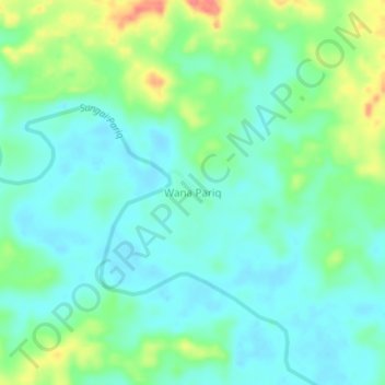
Nom : Carte topographique Wana Pariq, altitude, relief.
Lieu : Wana Pariq, Kalimantan oriental, Indonésie (0.26124 115.50989 0.30124 115.54989)
Altitude moyenne : 29 m
Altitude minimum : 10 m
Altitude maximum : 75 m
Autres cartes topographiques
Cliquez sur une carte pour visualiser sa topographie, son altitude et son relief.
Gunung Samarinda
Indonésie > Kalimantan oriental > Balikpapan
Gunung Samarinda, Balikpapan Utara, Balikpapan, Kalimantan oriental, Kalimantan, 76125, Indonésie
Altitude moyenne : 25 m
Nusantara
Indonésie > Kalimantan oriental > Nusantara
Nusantara, Kalimantan oriental, Indonésie
Altitude moyenne : 62 m
Klandasan Ilir
Indonésie > Kalimantan oriental > Balikpapan
Klandasan Ilir, Balikpapan, Kalimantan oriental, 76121, Indonésie
Altitude moyenne : 17 m
Random
Indonésie > Kalimantan oriental > Paser
Random, Paser, Kalimantan oriental, Indonésie
Altitude moyenne : 11 m
Tapis
Indonésie > Kalimantan oriental > Paser
Tapis, Paser, Kalimantan oriental, 76251, Indonésie
Altitude moyenne : 16 m
Prapatan
Indonésie > Kalimantan oriental > Prapatan
Prapatan, Kalimantan oriental, 76112, Indonésie
Altitude moyenne : 15 m