
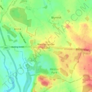
Carte topographique Weston under Lizard
Carte interactive
Cliquez sur la carte pour afficher l’altitude.
À propos de cette carte
Nom : Carte topographique Weston under Lizard, altitude, relief.
Altitude moyenne : 110 m
Altitude minimum : 85 m
Altitude maximum : 142 m
Autres cartes topographiques
Cliquez sur une carte pour visualiser sa topographie, son altitude et son relief.
Huntington
United Kingdom > England > Staffordshire > South Staffordshire
Huntington, South Staffordshire, Staffordshire, England, WS12 4TH, United Kingdom
Altitude moyenne : 166 m
Coven
United Kingdom > England > Staffordshire > South Staffordshire
Coven, South Staffordshire, Staffordshire, England, WV9 5BT, United Kingdom
Altitude moyenne : 104 m
Whiston
United Kingdom > England > Staffordshire > South Staffordshire > Penkridge
Whiston, Penkridge, South Staffordshire, Staffordshire, England, ST19 5QH, United Kingdom
Altitude moyenne : 95 m
Mottey Meadows NNR
United Kingdom > England > Staffordshire > South Staffordshire > Wheaton Aston
Mottey Meadows NNR, Lapley, Stretton and Wheaton Aston, Wheaton Aston, South Staffordshire, Staffordshire, England, United Kingdom
Altitude moyenne : 110 m
Halfpenny Green
United Kingdom > England > Staffordshire > South Staffordshire
Halfpenny Green, South Staffordshire, Staffordshire, England, DY7 5EJ, United Kingdom
Altitude moyenne : 91 m
Hatherton
United Kingdom > England > Staffordshire > South Staffordshire
Hatherton, South Staffordshire, Staffordshire, England, United Kingdom
Altitude moyenne : 128 m
Seisdon
United Kingdom > England > Staffordshire > South Staffordshire
Seisdon, South Staffordshire, Staffordshire, England, WV5 7HQ, United Kingdom
Altitude moyenne : 96 m
Highgate Common
United Kingdom > England > Staffordshire > South Staffordshire > Enville
Highgate Common, Enville, South Staffordshire, Staffordshire, England, United Kingdom
Altitude moyenne : 92 m
Calf Heath
United Kingdom > England > Staffordshire > South Staffordshire > Hatherton Junction
Calf Heath, Hatherton, Hatherton Junction, South Staffordshire, Staffordshire, England, WV10 7DW, United Kingdom
Altitude moyenne : 113 m
Acton Trussell
United Kingdom > England > Staffordshire > South Staffordshire
Acton Trussell, South Staffordshire, Staffordshire, England, ST17 0RQ, United Kingdom
Altitude moyenne : 93 m
Landywood
United Kingdom > England > Staffordshire > South Staffordshire
Cheslyn Hay, Landywood, South Staffordshire, Staffordshire, England, United Kingdom
Altitude moyenne : 136 m
Gospelash
United Kingdom > England > Staffordshire > South Staffordshire > Bobbington
Gospelash, Bobbington, Halfpenny Green, South Staffordshire, Staffordshire, England, DY7 5ED, United Kingdom
Altitude moyenne : 91 m
Trysull
United Kingdom > England > Staffordshire > South Staffordshire
Trysull, South Staffordshire, Staffordshire, England, WV5 7JF, United Kingdom
Altitude moyenne : 94 m
Essington
United Kingdom > England > Staffordshire > South Staffordshire
Essington, South Staffordshire, Staffordshire, England, United Kingdom
Altitude moyenne : 147 m
Stourton
United Kingdom > England > Staffordshire > South Staffordshire
Stourton, South Staffordshire, Staffordshire, England, DY7 5BG, United Kingdom
Altitude moyenne : 80 m
Penkridge
United Kingdom > England > Staffordshire > South Staffordshire
Penkridge, South Staffordshire, Staffordshire, England, United Kingdom
Altitude moyenne : 106 m
Kinver
United Kingdom > England > Staffordshire > South Staffordshire
Kinver, South Staffordshire, Staffordshire, England, United Kingdom
Altitude moyenne : 93 m
Himley
United Kingdom > England > Staffordshire > South Staffordshire > Himley
Himley, South Staffordshire, Staffordshire, West Midlands, England, DY3 4LB, United Kingdom
Altitude moyenne : 96 m
Hilton
United Kingdom > England > Staffordshire > South Staffordshire
Featherstone, Hilton, South Staffordshire, Staffordshire, England, United Kingdom
Altitude moyenne : 133 m
Cannock Lake
United Kingdom > England > Staffordshire > South Staffordshire > Huntington
Cannock Lake, Huntington, South Staffordshire, Staffordshire, West Midlands, England, United Kingdom
Altitude moyenne : 149 m
Bednall
United Kingdom > England > Staffordshire > South Staffordshire > Bednall
Bednall, South Staffordshire, Staffordshire, West Midlands, England, ST17 0SA, United Kingdom
Altitude moyenne : 118 m
Smestow
United Kingdom > England > Staffordshire > South Staffordshire
Smestow, South Staffordshire, Staffordshire, England, DY3 4PL, United Kingdom
Altitude moyenne : 91 m
Wombourne
United Kingdom > England > Staffordshire > South Staffordshire
Wombourne, South Staffordshire, Staffordshire, England, United Kingdom
Altitude moyenne : 112 m
Great Wyrley
United Kingdom > England > Staffordshire > South Staffordshire
Great Wyrley, South Staffordshire, Staffordshire, England, United Kingdom
Altitude moyenne : 138 m
Bilbrook
United Kingdom > England > Staffordshire > South Staffordshire
Codsall, Bilbrook, South Staffordshire, Staffordshire, England, United Kingdom
Altitude moyenne : 124 m
Blymhill
United Kingdom > England > Staffordshire > South Staffordshire
Blymhill, South Staffordshire, Staffordshire, England, TF11 8LW, United Kingdom
Altitude moyenne : 110 m
Hatherton Junction
United Kingdom > England > Staffordshire > South Staffordshire
Hatherton Junction, South Staffordshire, Staffordshire, England, WV10 7DU, United Kingdom
Altitude moyenne : 112 m
Perton
United Kingdom > England > Staffordshire > South Staffordshire
Perton, South Staffordshire, Staffordshire, England, United Kingdom
Altitude moyenne : 123 m
Bilbrook
United Kingdom > England > Staffordshire > South Staffordshire
Bilbrook, South Staffordshire, Staffordshire, England, WV8 1EU, United Kingdom
Altitude moyenne : 117 m
Wheaton Aston
United Kingdom > England > Staffordshire > South Staffordshire
Wheaton Aston, South Staffordshire, Staffordshire, England, ST19 9PT, United Kingdom
Altitude moyenne : 106 m
Brewood
United Kingdom > England > Staffordshire > South Staffordshire
Brewood, South Staffordshire, Staffordshire, England, ST19 9EH, United Kingdom
Altitude moyenne : 106 m
Shareshill
United Kingdom > England > Staffordshire > South Staffordshire
Shareshill, South Staffordshire, Staffordshire, England, WV10 7JS, United Kingdom
Altitude moyenne : 129 m
Enville
United Kingdom > England > Staffordshire > South Staffordshire
Enville, South Staffordshire, Staffordshire, England, United Kingdom
Altitude moyenne : 103 m