
Carte topographique Waterford
Carte interactive
Cliquez sur la carte pour afficher l’altitude.
À propos de cette carte
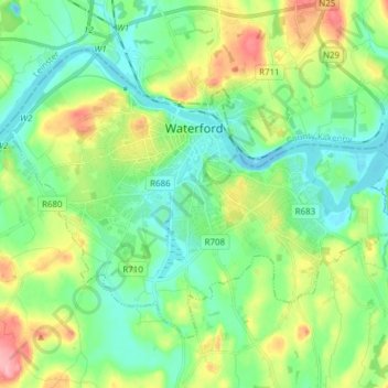
Nom : Carte topographique Waterford, altitude, relief.
Lieu : Waterford, Comté de Waterford, Munster, Irlande (52.21024 -7.18695 52.27982 -7.03388)
Altitude moyenne : 33 m
Altitude minimum : -5 m
Altitude maximum : 106 m
Autres cartes topographiques
Cliquez sur une carte pour visualiser sa topographie, son altitude et son relief.
Ballyduff
Ballyduff, The Municipal District of Dungarvan — Lismore, Comté de Waterford, Munster, Irlande
Altitude moyenne : 187 m
The Municipal District of Dungarvan — Lismore
The Municipal District of Dungarvan — Lismore, Comté de Waterford, Munster, Irlande
Altitude moyenne : 120 m
Native Woodland Trust:Grace Dieu Reserve
Native Woodland Trust:Grace Dieu Reserve, Gracedieu, Waterford City Metropolitan District, Comté de Waterford, Munster, Irlande
Altitude moyenne : 27 m
Waterford City Metropolitan District
Waterford City Metropolitan District, Comté de Waterford, Munster, Irlande
Altitude moyenne : 29 m
Dungarvan
Dungarvan, The Municipal District of Dungarvan — Lismore, Comté de Waterford, Munster, X35 V670, Irlande
Altitude moyenne : 30 m