
Carte topographique Evansville
Carte interactive
Cliquez sur la carte pour afficher l’altitude.
À propos de cette carte
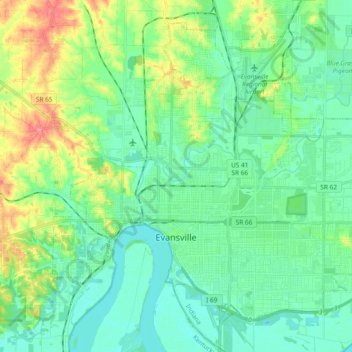
Nom : Carte topographique Evansville, altitude, relief.
Lieu : Evansville, Vanderburgh County, Indiana, United States (37.93559 -87.63755 38.05689 -87.44987)
Altitude moyenne : 122 m
Altitude minimum : 105 m
Altitude maximum : 179 m
Autres cartes topographiques
Cliquez sur une carte pour visualiser sa topographie, son altitude et son relief.
Country Club Meadows
United States > Indiana > Vanderburgh County > Evansville
Country Club Meadows, Evansville, Vanderburgh County, Indiana, 47710, United States
Altitude moyenne : 126 m
Darmstadt
United States > Indiana > Vanderburgh County
Darmstadt, Vanderburgh County, Indiana, United States
Altitude moyenne : 143 m